Search results
Jump to navigation
Jump to search

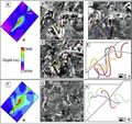
File:AlHawajAlQahtaniFigure6.jpg Examples from the deep-water Niger Delta of using channel geometry to constrain strike-slip displacement.[17] A)(468 × 439 (80 KB)) - 21:05, 8 November 2021- ...nomorph types is used to infer the depositional environments and extent of delta [[Depocenter#Sediment_supply_rate_and_facies_patterns|progradation]] during ...paleoenvironmental model of Middle Miocene reservoir units from the Niger Delta, which uses palynomorphs and organic matter to interpret more precisely the10 KB (1,252 words) - 19:55, 31 January 2022
- .... Courtesy of the [http://www.earthasart.gsfc.nasa.gov NASA Web site]. The delta is about 200 km (124 mi) across in this view. The photograph has been rotat ...or petroleum provinces include the Niger Delta in west Africa, the Mahakam Delta in Borneo, the Caspian Sea, and the Maracaibo Basin in Venezuela.34 KB (4,776 words) - 13:46, 26 August 2024
- ...ts using geological constraints, with applications to the deep-water Niger Delta: Journal of Structural Geology, v. 48, p. 33-44.</ref> A) Faulted horizon s ...AlQahtaniFigure6.jpg|Figure 6]] shows an example from the deep-water Niger Delta where 3D geomechanical restoration of strike-slip faults was enabled by uti17 KB (2,335 words) - 17:14, 13 October 2022
- ...is pattern of behavior is common in both the U.S. Gulf Coast and the Niger Delta.<ref name=ch10r93 />8 KB (1,130 words) - 17:14, 28 March 2022
- ...araná_Delta_near_Rosario.jpg|thumb|300px|Semi-flooded islands in the Upper Delta, off the coast of Rosario, Argentina. Photo by [https://commons.wikimedia.o ...ls, meandering channels (point bars and meander-belt deposits), lacustrine delta fill, backswamps, and flood plains (swamps, marshes, and freshwater lakes).33 KB (4,905 words) - 16:40, 6 April 2016
- ...m/data/specpubs/memoir93/CHAPTER09/CHAPTER09.HTM Mobile shale in the Niger Delta: Characteristics, structure, and evolution], ''in'' L. Wood, ed., Shale tec ...re Brunei and its implications for the early structural evolution of large delta systems]: Marine and Petroleum Geology, v. 17, p. 861–872.</ref>) because17 KB (2,466 words) - 16:16, 10 January 2024
- ...ial Neural Network (UANN) in characterizing reservoirs in Deep-water Niger Delta. In addition, from 3D seismic data, one of the main attributes is to extrac21 KB (3,096 words) - 20:59, 21 April 2022
- ...wnslope mass-movement processes. The seawardmost section of the subaqueous delta is commonly referred to as the prodelta environment and is composed of the ...ll overlie the uppermost parts of the subaqueous delta, forming a complete delta sequence.60 KB (9,022 words) - 17:17, 21 March 2016
- ...ut 12,000 m of sedimentary rocks is attained in the offshore western Niger delta, but maximum thicknesses of sedimentary rocks are about 2000 m in the Chad24 KB (3,689 words) - 17:46, 18 April 2019
- ...h has the largest deposit of uranium in the continent–241,000 metric tons; Niger; Namibia; Gabon; Algeria; Botswana; Central African Republic; and Chad. Oth ...gs at Awe in Nasarawa State and those in the onshore/offshore locations of Delta, Rivers, Cross Rivers, Edo, Bayelsa and Imo States. In addition, Nigeria is83 KB (12,860 words) - 14:03, 10 April 2019