Search results
Jump to navigation
Jump to search
There is a page named "Basin" on this wiki. See also the other search results found.
Page title matches
File:Sedimentary-basin-analysis fig4-27.png (1,707 × 740 (71 KB)) - 19:30, 30 January 2014
File:Sedimentary-basin-analysis fig4-6.png (712 × 747 (215 KB)) - 19:00, 30 January 2014
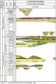
File:Sedimentary-basin-analysis fig4-39.png (1,632 × 1,133 (114 KB)) - 19:46, 30 January 2014- | title = Basin-centered gas systems The developmental history of a basin-centered gas system (BCGS) may be viewed as four reservoir pressure cycles.34 KB (4,772 words) - 14:44, 12 March 2019
File:Sedimentary-basin-analysis fig4-19.png (654 × 353 (116 KB)) - 19:16, 30 January 2014
File:Sedimentary-basin-analysis fig4-51.png (1,752 × 718 (111 KB)) - 20:03, 30 January 2014- #REDIRECT [[Plate tectonics and basin formation]]49 bytes (6 words) - 18:57, 27 July 2015
File:Sedimentary-basin-analysis fig4-2.png (600 × 564 (184 KB)) - 18:47, 30 January 2014
File:Sedimentary-basin-analysis fig4-31.png (2,056 × 2,081 (747 KB)) - 19:32, 30 January 2014
File:Sedimentary-basin-analysis fig4-11.png (692 × 885 (77 KB)) - 19:01, 30 January 2014
File:Sedimentary-basin-analysis fig4-42.png (1,475 × 1,016 (119 KB)) - 19:49, 30 January 2014- ...stratigraphic trap potential using the [[sequence stratigraphy]] approach. Basin-fill analysis is looking for [[Stratigraphic trap|stratigraphic]] or [[comb * [[Procedure for basin-fill analysis]]1 KB (189 words) - 18:53, 4 February 2022
File:Sedimentary-basin-analysis fig4-20.png (405 × 412 (13 KB)) - 19:17, 30 January 2014
File:Sedimentary-basin-analysis fig4-52.png (1,661 × 1,417 (1.01 MB)) - 20:04, 30 January 2014- | chapter = The Appalachian Basin Marcellus Gas Play: Its History of Development, Geologic Controls on Produc ...source rock, was not a significant hydrocarbon producer in the Appalachian Basin. This has changed greatly in the last few years.89 KB (13,415 words) - 19:16, 16 January 2024
- The Middle Devonian Marcellus Shale of the Appalachian Basin is the most extensive shale play in the U.S., covering about 66,600,000 acr ...ed gas resources in the Middle Devonian Marcellus Shale of the Appalachian Basin Province, 2019” (Higley and others, 2019). This fact sheet divided the Ma19 KB (2,773 words) - 21:36, 4 March 2022
File:Sedimentary-basin-analysis fig4-5.png (842 × 547 (115 KB)) - 18:49, 30 January 2014
File:Sedimentary-basin-analysis fig4-30.png (1,446 × 1,195 (405 KB)) - 19:34, 30 January 2014
File:Sedimentary-basin-analysis fig4-12.png (594 × 552 (86 KB)) - 19:03, 30 January 2014
File:Sedimentary-basin-analysis fig4-43.png (1,668 × 867 (534 KB)) - 19:50, 30 January 2014


Page text matches
File:MainPageBasinCenteredGasSystems.jpg Basin-centered gas systems: global distribution(400 × 408 (63 KB)) - 19:32, 13 July 2015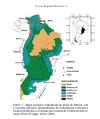
File:Parana 1.jpg Geological Map of the Paraná Basin. Milani E. J. 2004.(610 × 728 (86 KB)) - 17:38, 24 June 2015- ...pts], ''in'' Peters, Kenneth E., David J. Curry, and Marek Kacewicz, eds., Basin modeling: New horizons in research and applications: [http://store.aapg.org ...WnEw&sig2=PhylqTWS83U9eCDYb556qg&bvm=bv.70810081,d.aWw Australian Eromanga Basin]2 KB (268 words) - 19:15, 25 June 2015
- | chapter = Sedimentary basin analysis ...the distribution of sediments, and deform the contained rocks. Aspects of basin analysis, as presented in this chapter, focus on several scales:4 KB (512 words) - 16:26, 18 February 2022
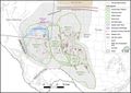
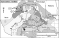
File:GiacomoneEtAlFigure6.jpg Location map of the Permian Basin, with its major structural features and drilled wells.(744 × 524 (88 KB)) - 20:03, 29 October 2021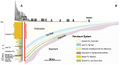
File:M114CH08FG02.jpg ...n of the siliciclastic sequence presents the main formations of the Llanos Basin. The early Paleocene Barcos (sandy) and Los Cuervos (shally) formations are(700 × 381 (50 KB)) - 18:09, 7 January 2019
File:H4CH12FG12.JPG ...Townsley, in Peters, Kenneth E., David J. Curry, and Marek Kacewicz, eds., Basin modeling: New horizons in research and applications: AAPG Hedberg Series no(600 × 346 (51 KB)) - 21:41, 13 July 2015- ...pts], ''in'' Peters, Kenneth E., David J. Curry, and Marek Kacewicz, eds., Basin modeling: New horizons in research and applications: [http://store.aapg.org703 bytes (90 words) - 19:50, 25 June 2015
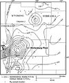
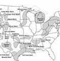
File:BasinCenteredGasFig14.jpg ...ard projection of the Colorado Mineral Belt (CMB). From Law, Ben E., 2002, Basin-centered gas systems: AAPG Bulletin, v. 86, no. 11, p. 1891-1919.(400 × 478 (53 KB)) - 16:30, 11 March 2015
File:H4CH12FG13.JPG ...Townsley, in Peters, Kenneth E., David J. Curry, and Marek Kacewicz, eds., Basin modeling: New horizons in research and applications: AAPG Hedberg Series no(600 × 480 (128 KB)) - 21:42, 13 July 2015
File:M114CH03FG03.jpg ...Formation reservoirs. By contrast, reservoirs in the southern part of the basin are at burial depths present day of ca. 3 km and have not been significantl(700 × 600 (112 KB)) - 17:49, 4 January 2019
File:H4CH12FG11.JPG ...Townsley, in Peters, Kenneth E., David J. Curry, and Marek Kacewicz, eds., Basin modeling: New horizons in research and applications: AAPG Hedberg Series no(600 × 322 (73 KB)) - 21:40, 13 July 2015- ...stratigraphic trap potential using the [[sequence stratigraphy]] approach. Basin-fill analysis is looking for [[Stratigraphic trap|stratigraphic]] or [[comb * [[Procedure for basin-fill analysis]]1 KB (189 words) - 18:53, 4 February 2022
File:Guara 02.jpg Stratigraphic diagram of Paraná Basin. Fm. Taquarembó is the Guará Formation correlate in Uruguay (from Milani,(1,113 × 1,648 (427 KB)) - 16:19, 24 June 2015
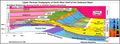
File:2.png Figure 2. Jurassic and Lower Cretaceous lithostratigraphy of the Neuquén Basin. Based on Spalletti & Veiga (2007).(376 × 491 (118 KB)) - 16:48, 26 June 2015- [[File:SanJuanBasinUSGS.jpg|thumb|300px|Map of San Juan Basin, Colorado-New Mexico, USA. U.S. Geological Survey.]] ...nd vicinity], in C. E. Turner-Peterson, E. S. Santos, and N. S. Fishman, A Basin Analysis Case Study: Morrison Formation, Grants Uranium Region, New Mexico:3 KB (411 words) - 15:01, 11 January 2016
- ...pts], ''in'' Peters, Kenneth E., David J. Curry, and Marek Kacewicz, eds., Basin modeling: New horizons in research and applications: [http://store.aapg.org688 bytes (93 words) - 19:04, 14 March 2016
File:GiacomoneEtAlFigure7.jpg Upper Permian Stratigraphy of North West Shelf of the Delaware Basin.(940 × 342 (119 KB)) - 20:03, 29 October 2021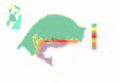
File:Guara 01.jpg Simplified geological map of Paraná Basin in Rio Grande do Sul state, Brazil. (modified from Scherer & Lavina, 2005)(3,364 × 2,331 (1.18 MB)) - 16:14, 24 June 2015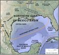
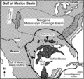
File:GiacomoneEtAlFigure4.jpg Location map of the United States (northern) Gulf of Mexico Super Basin.(678 × 626 (158 KB)) - 19:58, 29 October 2021


