Difference between revisions of "Siliciclastic shorelines and barrier island reservoirs"
Cwhitehurst (talk | contribs) |
Cwhitehurst (talk | contribs) |
||
| (35 intermediate revisions by 2 users not shown) | |||
| Line 13: | Line 13: | ||
| isbn = 0891813721 | | isbn = 0891813721 | ||
}} | }} | ||
| − | ==Shorelines and | + | ==Shorelines and Barrier Islands== |
| − | [[File:M91FG191.JPG|thumb|300px|{{figure number|1}}The photograph shows a shoreface profile on St. Cyrus Beach, Scotland. The beach is just over a hundred meters wide. Reservoir properties are influenced by the degree of wave reworking up the shoreface profile. Lower figure from McCubbin | + | [[File:M91FG191.JPG|thumb|300px|{{figure number|1}}The photograph shows a shoreface profile on St. Cyrus Beach, Scotland. The beach is just over a hundred meters wide. Reservoir properties are influenced by the degree of wave reworking up the shoreface profile. Lower figure from McCubbin.<ref name=McCubbin>McCubbin, D. G., 1992, [http://archives.datapages.com/data/bulletns/1986-87/data/pg/0070/0007/0800/0809.htm Barrier Islands, strand-plains], in P. A. Scholle and D. R. Spearing, eds., Sandstone depositional environments: [http://store.aapg.org/detail.aspx?id=627 AAPG Memoir 31], p. 247–279.</ref>]] |
Shoreface sands are deposited along shorelines, and they generally form extensive, high-quality reservoir systems ([[:File:M91FG191.JPG|Figure 1]]). Wave action and occasional storms act to deposit sand along the shoreface. The lower shoreface lies below fair-weather wave base but can be affected by storms; the sands tend to be siltier and more poorly sorted by comparison to the upper shoreface, where the sands have been subjected to wave winnowing. A shoreface deposit separated by a lagoon from the land is known as a barrier island. | Shoreface sands are deposited along shorelines, and they generally form extensive, high-quality reservoir systems ([[:File:M91FG191.JPG|Figure 1]]). Wave action and occasional storms act to deposit sand along the shoreface. The lower shoreface lies below fair-weather wave base but can be affected by storms; the sands tend to be siltier and more poorly sorted by comparison to the upper shoreface, where the sands have been subjected to wave winnowing. A shoreface deposit separated by a lagoon from the land is known as a barrier island. | ||
==Shoreface sands form layer-cake geometries== | ==Shoreface sands form layer-cake geometries== | ||
| − | Shoreface sands prograde by lateral accretion with a tendency to produce layer-cake tabular geometries. Depositional dead ends are rare within individual shoreface sandstones, and sweep efficiencies are generally high as a result; for example, Tyler and Ambrose | + | Shoreface sands prograde by [[lateral]] accretion with a tendency to produce layer-cake tabular geometries. Depositional dead ends are rare within individual shoreface sandstones, and sweep efficiencies are generally high as a result; for example, Tyler and Ambrose<ref name=TA1986>Tyler, N., and W. A. Ambrose, 1986, [http://archives.datapages.com/data/bulletns/1986-87/data/pg/0070/0007/0800/0809.htm Facies architecture and production characteristics of strand-plain reservoirs in North Markham-North Bay City field, Frio Formation, Texas]: AAPG Bulletin, v. 70, no. 7, p. 809–829.</ref> described excellent continuity and efficient simple sweep in the Carlson shoreface reservoir of the North Markham-North City Bay field of Texas. The large size and excellent lateral continuity of shoreface reservoirs give a reasonable chance that these systems will be in contact with an aquifer (Table 1): |
| − | [[ | + | {| class="wikitable" |
| + | |- | ||
| + | |+ {{table number|1}}Factors influencing connectivity and reservoir development in siliciclastic shorelines | ||
| + | and barrier island reservoirs. | ||
| + | |- | ||
| + | ! Characteristic !! Favorable for Reservoir Development !! Unfavorable for Reservoir Development | ||
| + | |- | ||
| + | | Shoreface sandstones often show layer-cake tabular geometries || Excellent lateral continuity, high sweep efficiency, aquifers common || | ||
| + | |- | ||
| + | | Shoreface sandstones commonly stack in parasequence sets || || Marine-flooding shales may create poor to no vertical connectivity between individual parasequences | ||
| + | |- | ||
| + | | Shoreface sandstones show upward-increasing permeability profiles || Favorable to high vertical sweep efficiencies || | ||
| + | |- | ||
| + | | Poor vertical permeability at upper to lower shoreface boundaries (e.g., mica plating) || || Lower shoreface sediments may be poorly swept; horizontal wells may improve sweep in favorable circumstances | ||
| + | |- | ||
| + | | Extensive layer-parallel carbonate cements below flooding surfaces || || Poor vertical connectivity | ||
| + | |- | ||
| + | | Mud-filled interridge swales in strand-plain sandstones || || Can create barriers to vertical flow with compartmentalization | ||
| + | |- | ||
| + | | Common tidal and fluvial channel fills || || Permeability contrast with shore face or barrier island sandstones can result in bypassed oil | ||
| + | |- | ||
| + | | Lagoonal sandstone bodies (washover fans and flood-tidal deltas) can be wholly or partially enclosed in [[mudstone]] || || Can form discrete hydraulic units or compartments with bypassed oil | ||
| + | |} | ||
==Parasequences and parasequence sets== | ==Parasequences and parasequence sets== | ||
<gallery mode=packed heights=300px widths=300px> | <gallery mode=packed heights=300px widths=300px> | ||
| − | M91Ch11FG73.JPG|{{figure number|2}}Lithofacies map for the upper Piper Sand interval of the Scott field, UK North Sea (from Guscott et al., 2003). Reprinted with permission from the Geological Society. | + | M91Ch11FG73.JPG|{{figure number|2}}[[Lithofacies map]] for the upper Piper Sand interval of the Scott field, UK North Sea (from Guscott et al.<ref name=Guscott>Guscott, S., K. Russell, A. Thickpenny, and R. Poddubiuk, 2003, The Scott field, Blocks 15/21a, 15/22, UK North Sea, in J. G. Gluyas and H. M. Hichens, eds., United Kingdom oil and gas fields, commemorative millennium volume: Geological Society (London) Memoir 20, p. 467–481.</ref>). Reprinted with permission from, and © by, the Geological Society. See also Lithofacies maps<ref>Shepherd, M., 2009, [http://archives.datapages.com/data/specpubs/memoir91/CHAPTER11/CHAPTER11.HTM Lithofacies maps], in M. Shepherd, Oil field production geology: [http://store.aapg.org/detail.aspx?id=788 AAPG Memoir 91], p. 93-98. |
M91FG102.JPG|{{figure number|3}}Vertical flow barriers can control the drainage patterns in a reservoir. The degree to which individual barriers are effective across the reservoir can be characterized by vertical flow barrier maps. | M91FG102.JPG|{{figure number|3}}Vertical flow barriers can control the drainage patterns in a reservoir. The degree to which individual barriers are effective across the reservoir can be characterized by vertical flow barrier maps. | ||
</gallery> | </gallery> | ||
| − | Shoreface sandstones commonly form parasequence sets | + | Shoreface sandstones commonly form parasequence sets. An individual parasequence can comprise a series of facies belts showing a progression from coastal to offshore sediments. For example, in the Scott field in the UK North Sea, back barrier, foreshore, upper shoreface, and lower shoreface facies belts can be mapped out in the Upper Piper Sandstone Member (see [[:File:M91Ch11FG73.JPG|Figure 2]]).<ref name=Guscott /> An analysis of parasequence stacking patterns can help the geologist to predict and map facies belts in the areas beyond the well control. For example, Spaak et al.<ref>Spaak, P., J. Almond, S. Salahudin, Z. Mohd Salleh, and O. Tosun, 1999, Fulmar: A mature field revisited, in A. J. Fleet and S. A. R. Boldy, eds., Petroleum geology of northwest Europe: Proceedings of the 5th Conference, Geological Society (London), p. 1089–1100.</ref> used stacking analysis on the Jurassic shoreface sediments of the Fulmar field, UK North Sea, to help construct the depositional scheme for the reservoir. |
| − | The basal section of individual parasequences is defined by a flooding surface that is commonly a marine shale. Shales can isolate individual parasequence shoreface cycles vertically, and they can be laterally extensive for several hundreds of meters or more. Fluid flow communication may occur between parasequences where the shales are absent as a result of erosion or nondeposition. It can be useful to produce vertical flow barrier maps for parasequence boundaries (see [[:File:M91FG102.JPG|Figure 3]]). The localized presence or absence of bounding shales can be a critical feature in the flow geology characterization of a shoreface reservoir | + | The basal section of individual parasequences is defined by a flooding surface that is commonly a marine shale. Shales can isolate individual parasequence shoreface cycles vertically, and they can be laterally extensive for several hundreds of meters or more. Fluid flow communication may occur between parasequences where the shales are absent as a result of erosion or nondeposition. It can be useful to produce vertical flow barrier maps for parasequence boundaries (see [[:File:M91FG102.JPG|Figure 3]]). The localized presence or absence of bounding shales can be a critical feature in the flow geology characterization of a shoreface reservoir.<ref>Larue, D. K., and H. Legarre, 2004, [http://archives.datapages.com/data/bulletns/2004/03mar/0303/0303.HTM Flow units, connectivity, and reservoir characterization in a wave-dominated reservoir: Meren reservoir, Nigeria]: AAPG Bulletin, v. 88, no. 3, p. 303–324.</ref> |
==Vertical permeability profiles in shoreface sandstones== | ==Vertical permeability profiles in shoreface sandstones== | ||
<gallery mode=packed heights=300px widths=300px> | <gallery mode=packed heights=300px widths=300px> | ||
| − | M91Ch6FG42.JPG|{{figure number|4}}Example of a sedimentological core log, Well d-2-C/94a-16, Peejay field, Canada (after Caplan and Moslow, 1999 | + | M91Ch6FG42.JPG|{{figure number|4}}Example of a sedimentological core log, Well d-2-C/94a-16, Peejay field, Canada (after Caplan and Moslow).<ref>Caplan, M. L., and T. F. Moslow, 1999, [http://archives.datapages.com/data/bulletns/1999/01jan/0128/0128.htm Depositional origin and facies variability of a Middle Triassic barrier island complex, Peejay field, northeastern British Columbia]: AAPG Bulletin, v. 83, no. 1, p. 128–154.</ref> From Shepherd.<ref>Shepherd, M., 2009, [http://archives.datapages.com/data/specpubs/memoir91/CHAPTER06/CHAPTER06.HTM Sources of data], in M. Shepherd, Oil field production geology: [http://store.aapg.org/detail.aspx?id=788 AAPG Memoir 91], p. 49-63. |
| − | M91FG108.JPG|{{figure number|5}}The barrier bar-shoreface interval of the Brent Group reservoir in the Thistle field, UK North Sea, shows an upward-increasing permeability profile. This pattern is favorable to a high sweep efficiency (from Williams and Milne, 1991). Reprinted with permission from the Geological Society. | + | M91FG108.JPG|{{figure number|5}}The barrier bar-shoreface interval of the Brent Group reservoir in the Thistle field, UK North Sea, shows an upward-increasing permeability profile. This pattern is favorable to a high sweep efficiency (from Williams and Milne).<ref>Williams, R. R., and A. D. Milne, 1991, The Thistle field, Blocks 211/18a and 211/19, UK North Sea, in I. L. Abbots, ed., United Kingdom oil and gas fields, 25 years commemorative volume: Geological Society (London) Memoir 14, p. 199–207.</ref> Reprinted with permission from, and © by, the Geological Society. |
</gallery> | </gallery> | ||
| − | Shoreface sandstones characteristically show upward-increasing permeability profiles. This in turn reflects increasing grain size and better sorting higher up the shoreface profile (see also [[:File:M91Ch6FG42.JPG|Figures 4]] and [[:File:M91FG108.JPG|5]]). A contrast in rock properties is characteristically seen between the lower and upper shoreface intervals. Upper shoreface beach facies associations generally show higher permeabilities than lower shoreface sediments. When a shoreface sand is subjected to a waterflood, the water tends to edge ahead through the high-permeability tops of these cycles by viscous forces. Gravity and capillary action will then draw the water down through the shoreface cycle into the lower units, displacing oil upward. Sweep efficiencies can be high as a result. | + | Shoreface sandstones characteristically show upward-increasing permeability profiles. This in turn reflects increasing [[grain size]] and better sorting higher up the shoreface profile (see also [[:File:M91Ch6FG42.JPG|Figures 4]] and [[:File:M91FG108.JPG|5]]). A contrast in rock properties is characteristically seen between the lower and upper shoreface intervals. Upper shoreface beach facies associations generally show higher permeabilities than lower shoreface sediments. When a shoreface sand is subjected to a waterflood, the water tends to edge ahead through the high-permeability tops of these cycles by viscous forces. [[Gravity]] and capillary action will then draw the water down through the shoreface cycle into the lower units, displacing oil upward. Sweep efficiencies can be high as a result. |
| − | The degree to which the lower part of the shoreface is swept by water will depend on the magnitude of the vertical permeability within the lower shoreface. In the Middle Jurassic Brent Province of the UK North Sea, bypassed oil is often found within the lower shoreface facies association (Rannoch Formation). The overlying upper shoreface (Etive Formation) is typically an interval of water overrun | + | The degree to which the lower part of the shoreface is swept by water will depend on the magnitude of the vertical permeability within the lower shoreface. In the Middle Jurassic Brent Province of the UK North Sea, bypassed oil is often found within the lower shoreface facies association (Rannoch Formation). The overlying upper shoreface (Etive Formation) is typically an interval of water overrun.<ref>Thomas, J. M. D., and R. Bibby, 1991, The depletion of the Rannoch-Etive sand unit in Brent sands reservoirs in the North Sea, in W. Linville, ed., Reservoir characterization III: Tulsa, PennWell Books, 1008 p.</ref> This behavior can be reinforced by a zone of mica concentration at the top of the lower shoreface, which acts as a baffle to vertical flow (Wetzelaer et al., 1996). Horizontal wells have been drilled in several Brent Province fields to target bypassed oil in the lower shore face.<ref>Braithwaite, C. I. M., J. D. Marshall, and T. C. Holland, 1989, Improving recovery from the Dunlin field, U.K. northern North Sea: Presented at the 54th Annual Technical Conference of the Society of Petroleum Engineers, San Antonio, Texas, SPE Paper 19878, 18 p.</ref><ref>Black, R. C., H. J. Poelen, M. J. Roberts, and S. E. Roddy, 1999, Tern field development: A marriage of new technologies for business benefit, in A. J. Fleet and S. A. R. Boldy, eds., Petroleum geology of northwest Europe: Proceedings of the 5th Conference, Geological Society (London), p. 1063–1073.</ref> The success of these wells depends on the presence of low vertical permeabilities at the top of the lower shoreface interval in order to prevent water coning down from the swept upper shoreface interval. |
| − | Shallow marine sandstones can contain extensive stratiform carbonate-cemented bands and nodules. Taylor et al. | + | |
| + | Shallow marine sandstones can contain extensive stratiform carbonate-cemented bands and nodules. Taylor et al.<ref>Taylor, K. G., R. L. Gawthorpe, and J. C. Van Wagoner, 1995, Stratigraphic control on laterally persistent cementation, Book Cliffs, Utah: Journal of the Geological Society, v. 152, p. 225–228.</ref> found widespread cemented intervals below major flooding surfaces in the Upper Cretaceous Blackhawk Formation in Utah. The reduced sedimentation rates associated with these surfaces are thought to have allowed more time for cements to form. The cemented horizons have the potential to form baffles. | ||
==Beach sandstones== | ==Beach sandstones== | ||
| − | [[File:M91FG117.JPG|thumb|300px|{{figure number|6}}Time series of water cut maps from the West Cornelius reservoir, North Markham-North Bay City field, Texas. In this strand-plain reservoir, east-northeastndashwest-southwest-oriented beach ridge macroforms are fairways for water ingress. Tidal mud flat deposits south of the field restrict water influx from this direction (from Tyler and Ambrose | + | [[File:M91FG117.JPG|thumb|300px|{{figure number|6}}Time series of water cut maps from the West Cornelius reservoir, North Markham-North Bay City field, Texas. In this strand-plain reservoir, east-northeastndashwest-southwest-oriented beach ridge macroforms are fairways for water ingress. Tidal mud flat deposits south of the field restrict water influx from this direction (from Tyler and Ambrose.<ref name=TA1986 />)]] |
| − | Beach sandstones form as single belts or accrete laterally to form strand plains many kilometers long and several kilometers wide. Modern strand plains such as the Nayarit strand plain of western Mexico show a ridge and swale topography on their surfaces | + | Beach sandstones form as single belts or accrete laterally to form strand plains many kilometers long and several kilometers wide. Modern strand plains such as the Nayarit strand plain of western Mexico show a ridge and swale topography on their surfaces.<ref name=McCubbin /> Mud fills in the interridge swales can act as permeability barriers to lateral flow in the subsurface. One example in the Frio Formation of south Texas is known to have caused the compartmentalization of a beach ridge interval containing several million barrels of recoverable oil.<ref>Reistroffer, J. R., and N. Tyler, 1991, Depositional environments and reservoir compartmentalization within the Frio zone 21-B reservoir, Tijerina-Canales-Blucher field, South Texas (abs.): Transactions of the Gulf Coast Association of Geological Societies, v. 41, p. 559–560.</ref> Water ingress may preferentially occur along the low-lying swales<ref name=TA1986 /> ([[:File:M91FG117.JPG|Figure 6]]). |
==Tidal channels== | ==Tidal channels== | ||
| Line 53: | Line 76: | ||
==Barrier Islands== | ==Barrier Islands== | ||
| − | [[File:M91FG192.JPG|thumb|300px|{{figure number|7}}Generalized map and cross sections showing major environments and facies associations of a barrier island-lagoonal system (from McCubbin | + | [[File:M91FG192.JPG|thumb|300px|{{figure number|7}}Generalized map and cross sections showing major environments and facies associations of a barrier island-lagoonal system (from McCubbin<ref name=McCubbin />). Reprinted with permission from the AAPG.]] |
| − | Barrier islands form thick, well-sorted sand bodies with a tabular geometry ([[:File:M91FG192.JPG|Figure 7]]). They typically comprise a composite of beach, dune, and upper shoreface sandstones | + | Barrier islands form thick, well-sorted sand bodies with a tabular geometry ([[:File:M91FG192.JPG|Figure 7]]). They typically comprise a composite of beach, dune, and upper shoreface sandstones.<ref name=Galloway1986>Galloway, W. E., 1986, [http://archives.datapages.com/data/bulletns/1986-87/data/pg/0070/0007/0750/0787.htm Reservoir facies architecture of microtidal barrier systems]: AAPG Bulletin, v. 70, no. 7, p. 787–808.</ref> Barrier islands can be continuous for tens of kilometers along strike but may only be a few kilometers wide. Local heterogeneity can be provided by tidal channel inlet deposits. These form crosscutting lenticular pods, disrupting the layer-cake continuity of the barrier island body. Recent barrier island sediments on the South Carolina coast provide a modern analog and are described in detail by Sexton and Hayes.<ref>Sexton, W. J., and M. O. Hayes, 1996, [http://archives.datapages.com/data/bulletns/1994-96/data/pg/0080/0006/0800/0831.htm Holocene deposits of reservoir-quality sand along the central South Carolina coastline]: AAPG Bulletin, v. 80, no. 6, p. 831–854.</ref> |
| − | Ambrose et al. | + | Ambrose et al.<ref>Ambrose, W. A., F. P. Wang, M. S. Akhter, and J. Skolnakorn, 1997, Geologic controls on remaining oil in Miocene transgressive-barrier, coastal-plain, and mixed-load fluvial systems in the Miocene Norte area, Lake Maracaibo, Venezuela: Presented at the Society of Petroleum Engineers Annual Technical Conference and Exhibition, October 5–8, San Antonio, Texas, SPE Paper 38662, 10 p.</ref> gave an example from an oil field in Venezuela where sweep has resulted from preferential water encroachment along the sandstone-rich core of the barrier island depositional axis with bypassed oil remaining along the landward pinch-out edge. |
| − | Richardson et al. | + | Richardson et al.<ref>Richardson, J. G., J. B. Sangree, and R. M. Sneider, 1988, Coastal barrier reservoirs: Journal of Petroleum Technology, v. 40, no. 9, p. 1127–1128.</ref> noted that severe problems can arise where barrier islands show a jigsaw-puzzle arrangement with poorer quality and discontinuous macroforms. Displacing fluids are channeled through the barrier island sandstones and bypass the other units. Efforts should be made to target the poorer quality intervals for this reason. Ambrose et al.<ref>Ambrose, W. A., N. Tyler, and M. J. Parsley, 1991, Facies heterogeneity, pay continuity, and infill potential in barrier-island, fluvial, and submarine-fan reservoirs: Examples from the Texas Gulf Coast and Midland Basin, in A. D. Miall and N. Tyler, eds., The three-dimensional facies architecture of terrigenous clastic sediments and its implication for hydrocarbon discovery and recovery: SEPM Concepts in Sedimentology and Paleontology 3, p. 13–21.</ref> described a relatively low-permeability tidal inlet channel within the high-permeability barrier island facies association of the West Ranch reservoir of the Frio barrier-strand-plain play of Texas. Unswept oil is commonly found within the tidal inlet sand bodies or along the permeability contrast marking the boundary between the tidal inlet sediments and the enclosing barrier island sandstones. |
==Back-barrier environments== | ==Back-barrier environments== | ||
| − | Background deposition within the lagoon behind the barrier island is generally mud, but with some sand bodies present. These include washover fans and flood-tidal deltas ([[Figure | + | Background deposition within the lagoon behind the barrier island is generally mud, but with some sand bodies present. These include washover fans and flood-tidal deltas ([[:File:M91FG192.JPG|Figure 7]]). Washover fans form when storms pitch sand over the barrier bar into the lagoonal area. Flood-tidal deltas develop as a result of the tidal movement of sand through an inlet into the lagoon. These lagoonal sand bodies are characterized by a pinch-out geometry into the lagoonal shales. The shales interfinger with the sandstones, commonly enveloping the sandstones and sometimes isolating them as discrete hydraulic units. |
| − | Washover sandstone complexes may be rather patchy and laterally heterogeneous. Production from washover sandstones in the Glasscock reservoir of the West Ranch field in Texas is described by Galloway | + | Washover sandstone complexes may be rather patchy and laterally heterogeneous. Production from washover sandstones in the Glasscock reservoir of the West Ranch field in Texas is described by Galloway.<ref name=Galloway1986 /> Waterflooding has proceeded irregularly with injected water preferentially flowing along the washover channels. As a result, the Glasscock reservoir has the lowest projected recovery factor (38%) of all the major intervals in the West Ranch field. |
| + | |||
| + | ==See also== | ||
| + | * [[Eolian reservoirs]] | ||
| + | * [[Braided fluvial reservoirs]] | ||
| + | * [[Deltaic reservoirs]] | ||
| + | * [[Meandering fluvial reservoirs]] | ||
| + | * [[Deep-water marine reservoirs]] | ||
| + | * [[Carbonate reservoir]] | ||
| + | |||
| + | ==References== | ||
| + | {{reflist}} | ||
Latest revision as of 15:33, 15 January 2024
| Oil Field Production Geology | |

| |
| Series | Memoirs |
|---|---|
| Part | The Production Geologist and the Reservoir |
| Chapter | Eolian reservoirs |
| Author | Mike Shepherd |
| Link | Web page |
| PDF file (requires access) | |
| Store | AAPG Store |
Shorelines and Barrier Islands

Shoreface sands are deposited along shorelines, and they generally form extensive, high-quality reservoir systems (Figure 1). Wave action and occasional storms act to deposit sand along the shoreface. The lower shoreface lies below fair-weather wave base but can be affected by storms; the sands tend to be siltier and more poorly sorted by comparison to the upper shoreface, where the sands have been subjected to wave winnowing. A shoreface deposit separated by a lagoon from the land is known as a barrier island.
Shoreface sands form layer-cake geometries
Shoreface sands prograde by lateral accretion with a tendency to produce layer-cake tabular geometries. Depositional dead ends are rare within individual shoreface sandstones, and sweep efficiencies are generally high as a result; for example, Tyler and Ambrose[2] described excellent continuity and efficient simple sweep in the Carlson shoreface reservoir of the North Markham-North City Bay field of Texas. The large size and excellent lateral continuity of shoreface reservoirs give a reasonable chance that these systems will be in contact with an aquifer (Table 1):
| Characteristic | Favorable for Reservoir Development | Unfavorable for Reservoir Development |
|---|---|---|
| Shoreface sandstones often show layer-cake tabular geometries | Excellent lateral continuity, high sweep efficiency, aquifers common | |
| Shoreface sandstones commonly stack in parasequence sets | Marine-flooding shales may create poor to no vertical connectivity between individual parasequences | |
| Shoreface sandstones show upward-increasing permeability profiles | Favorable to high vertical sweep efficiencies | |
| Poor vertical permeability at upper to lower shoreface boundaries (e.g., mica plating) | Lower shoreface sediments may be poorly swept; horizontal wells may improve sweep in favorable circumstances | |
| Extensive layer-parallel carbonate cements below flooding surfaces | Poor vertical connectivity | |
| Mud-filled interridge swales in strand-plain sandstones | Can create barriers to vertical flow with compartmentalization | |
| Common tidal and fluvial channel fills | Permeability contrast with shore face or barrier island sandstones can result in bypassed oil | |
| Lagoonal sandstone bodies (washover fans and flood-tidal deltas) can be wholly or partially enclosed in mudstone | Can form discrete hydraulic units or compartments with bypassed oil |
Parasequences and parasequence sets
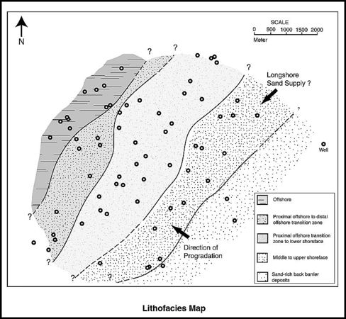
Figure 2 Lithofacies map for the upper Piper Sand interval of the Scott field, UK North Sea (from Guscott et al.[3]). Reprinted with permission from, and © by, the Geological Society. See also Lithofacies maps<ref>Shepherd, M., 2009, Lithofacies maps, in M. Shepherd, Oil field production geology: AAPG Memoir 91, p. 93-98.
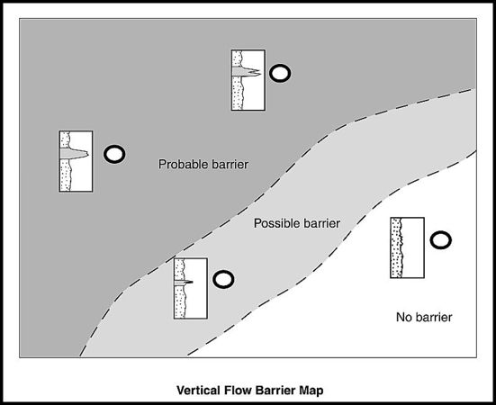
Figure 3 Vertical flow barriers can control the drainage patterns in a reservoir. The degree to which individual barriers are effective across the reservoir can be characterized by vertical flow barrier maps.


Shoreface sandstones commonly form parasequence sets. An individual parasequence can comprise a series of facies belts showing a progression from coastal to offshore sediments. For example, in the Scott field in the UK North Sea, back barrier, foreshore, upper shoreface, and lower shoreface facies belts can be mapped out in the Upper Piper Sandstone Member (see Figure 2).[3] An analysis of parasequence stacking patterns can help the geologist to predict and map facies belts in the areas beyond the well control. For example, Spaak et al.[4] used stacking analysis on the Jurassic shoreface sediments of the Fulmar field, UK North Sea, to help construct the depositional scheme for the reservoir.
The basal section of individual parasequences is defined by a flooding surface that is commonly a marine shale. Shales can isolate individual parasequence shoreface cycles vertically, and they can be laterally extensive for several hundreds of meters or more. Fluid flow communication may occur between parasequences where the shales are absent as a result of erosion or nondeposition. It can be useful to produce vertical flow barrier maps for parasequence boundaries (see Figure 3). The localized presence or absence of bounding shales can be a critical feature in the flow geology characterization of a shoreface reservoir.[5]
Vertical permeability profiles in shoreface sandstones
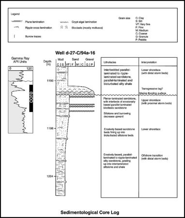
Figure 4 Example of a sedimentological core log, Well d-2-C/94a-16, Peejay field, Canada (after Caplan and Moslow).[6] From Shepherd.<ref>Shepherd, M., 2009, Sources of data, in M. Shepherd, Oil field production geology: AAPG Memoir 91, p. 49-63.
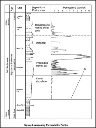
Figure 5 The barrier bar-shoreface interval of the Brent Group reservoir in the Thistle field, UK North Sea, shows an upward-increasing permeability profile. This pattern is favorable to a high sweep efficiency (from Williams and Milne).[7] Reprinted with permission from, and © by, the Geological Society.


Shoreface sandstones characteristically show upward-increasing permeability profiles. This in turn reflects increasing grain size and better sorting higher up the shoreface profile (see also Figures 4 and 5). A contrast in rock properties is characteristically seen between the lower and upper shoreface intervals. Upper shoreface beach facies associations generally show higher permeabilities than lower shoreface sediments. When a shoreface sand is subjected to a waterflood, the water tends to edge ahead through the high-permeability tops of these cycles by viscous forces. Gravity and capillary action will then draw the water down through the shoreface cycle into the lower units, displacing oil upward. Sweep efficiencies can be high as a result.
The degree to which the lower part of the shoreface is swept by water will depend on the magnitude of the vertical permeability within the lower shoreface. In the Middle Jurassic Brent Province of the UK North Sea, bypassed oil is often found within the lower shoreface facies association (Rannoch Formation). The overlying upper shoreface (Etive Formation) is typically an interval of water overrun.[8] This behavior can be reinforced by a zone of mica concentration at the top of the lower shoreface, which acts as a baffle to vertical flow (Wetzelaer et al., 1996). Horizontal wells have been drilled in several Brent Province fields to target bypassed oil in the lower shore face.[9][10] The success of these wells depends on the presence of low vertical permeabilities at the top of the lower shoreface interval in order to prevent water coning down from the swept upper shoreface interval.
Shallow marine sandstones can contain extensive stratiform carbonate-cemented bands and nodules. Taylor et al.[11] found widespread cemented intervals below major flooding surfaces in the Upper Cretaceous Blackhawk Formation in Utah. The reduced sedimentation rates associated with these surfaces are thought to have allowed more time for cements to form. The cemented horizons have the potential to form baffles.
Beach sandstones

Beach sandstones form as single belts or accrete laterally to form strand plains many kilometers long and several kilometers wide. Modern strand plains such as the Nayarit strand plain of western Mexico show a ridge and swale topography on their surfaces.[1] Mud fills in the interridge swales can act as permeability barriers to lateral flow in the subsurface. One example in the Frio Formation of south Texas is known to have caused the compartmentalization of a beach ridge interval containing several million barrels of recoverable oil.[12] Water ingress may preferentially occur along the low-lying swales[2] (Figure 6).
Tidal channels
Although shoreface sandstones typically show a simple layer-cake geometry with minor internal heterogeneity, some reservoirs may contain an element of jigsaw-puzzle geometry provided by tidal and fluvial channel fills. Tidal channels may migrate laterally with sand accreting to form long, thin, sheet-like bodies parallel to the shoreface. Bypassed oil volumes may be found within tidal channel macroforms in shoreface sandstone intervals.
Barrier Islands

Barrier islands form thick, well-sorted sand bodies with a tabular geometry (Figure 7). They typically comprise a composite of beach, dune, and upper shoreface sandstones.[13] Barrier islands can be continuous for tens of kilometers along strike but may only be a few kilometers wide. Local heterogeneity can be provided by tidal channel inlet deposits. These form crosscutting lenticular pods, disrupting the layer-cake continuity of the barrier island body. Recent barrier island sediments on the South Carolina coast provide a modern analog and are described in detail by Sexton and Hayes.[14]
Ambrose et al.[15] gave an example from an oil field in Venezuela where sweep has resulted from preferential water encroachment along the sandstone-rich core of the barrier island depositional axis with bypassed oil remaining along the landward pinch-out edge.
Richardson et al.[16] noted that severe problems can arise where barrier islands show a jigsaw-puzzle arrangement with poorer quality and discontinuous macroforms. Displacing fluids are channeled through the barrier island sandstones and bypass the other units. Efforts should be made to target the poorer quality intervals for this reason. Ambrose et al.[17] described a relatively low-permeability tidal inlet channel within the high-permeability barrier island facies association of the West Ranch reservoir of the Frio barrier-strand-plain play of Texas. Unswept oil is commonly found within the tidal inlet sand bodies or along the permeability contrast marking the boundary between the tidal inlet sediments and the enclosing barrier island sandstones.
Back-barrier environments
Background deposition within the lagoon behind the barrier island is generally mud, but with some sand bodies present. These include washover fans and flood-tidal deltas (Figure 7). Washover fans form when storms pitch sand over the barrier bar into the lagoonal area. Flood-tidal deltas develop as a result of the tidal movement of sand through an inlet into the lagoon. These lagoonal sand bodies are characterized by a pinch-out geometry into the lagoonal shales. The shales interfinger with the sandstones, commonly enveloping the sandstones and sometimes isolating them as discrete hydraulic units. Washover sandstone complexes may be rather patchy and laterally heterogeneous. Production from washover sandstones in the Glasscock reservoir of the West Ranch field in Texas is described by Galloway.[13] Waterflooding has proceeded irregularly with injected water preferentially flowing along the washover channels. As a result, the Glasscock reservoir has the lowest projected recovery factor (38%) of all the major intervals in the West Ranch field.
See also
- Eolian reservoirs
- Braided fluvial reservoirs
- Deltaic reservoirs
- Meandering fluvial reservoirs
- Deep-water marine reservoirs
- Carbonate reservoir
References
- ↑ 1.0 1.1 1.2 McCubbin, D. G., 1992, Barrier Islands, strand-plains, in P. A. Scholle and D. R. Spearing, eds., Sandstone depositional environments: AAPG Memoir 31, p. 247–279.
- ↑ 2.0 2.1 2.2 Tyler, N., and W. A. Ambrose, 1986, Facies architecture and production characteristics of strand-plain reservoirs in North Markham-North Bay City field, Frio Formation, Texas: AAPG Bulletin, v. 70, no. 7, p. 809–829.
- ↑ 3.0 3.1 Guscott, S., K. Russell, A. Thickpenny, and R. Poddubiuk, 2003, The Scott field, Blocks 15/21a, 15/22, UK North Sea, in J. G. Gluyas and H. M. Hichens, eds., United Kingdom oil and gas fields, commemorative millennium volume: Geological Society (London) Memoir 20, p. 467–481.
- ↑ Spaak, P., J. Almond, S. Salahudin, Z. Mohd Salleh, and O. Tosun, 1999, Fulmar: A mature field revisited, in A. J. Fleet and S. A. R. Boldy, eds., Petroleum geology of northwest Europe: Proceedings of the 5th Conference, Geological Society (London), p. 1089–1100.
- ↑ Larue, D. K., and H. Legarre, 2004, Flow units, connectivity, and reservoir characterization in a wave-dominated reservoir: Meren reservoir, Nigeria: AAPG Bulletin, v. 88, no. 3, p. 303–324.
- ↑ Caplan, M. L., and T. F. Moslow, 1999, Depositional origin and facies variability of a Middle Triassic barrier island complex, Peejay field, northeastern British Columbia: AAPG Bulletin, v. 83, no. 1, p. 128–154.
- ↑ Williams, R. R., and A. D. Milne, 1991, The Thistle field, Blocks 211/18a and 211/19, UK North Sea, in I. L. Abbots, ed., United Kingdom oil and gas fields, 25 years commemorative volume: Geological Society (London) Memoir 14, p. 199–207.
- ↑ Thomas, J. M. D., and R. Bibby, 1991, The depletion of the Rannoch-Etive sand unit in Brent sands reservoirs in the North Sea, in W. Linville, ed., Reservoir characterization III: Tulsa, PennWell Books, 1008 p.
- ↑ Braithwaite, C. I. M., J. D. Marshall, and T. C. Holland, 1989, Improving recovery from the Dunlin field, U.K. northern North Sea: Presented at the 54th Annual Technical Conference of the Society of Petroleum Engineers, San Antonio, Texas, SPE Paper 19878, 18 p.
- ↑ Black, R. C., H. J. Poelen, M. J. Roberts, and S. E. Roddy, 1999, Tern field development: A marriage of new technologies for business benefit, in A. J. Fleet and S. A. R. Boldy, eds., Petroleum geology of northwest Europe: Proceedings of the 5th Conference, Geological Society (London), p. 1063–1073.
- ↑ Taylor, K. G., R. L. Gawthorpe, and J. C. Van Wagoner, 1995, Stratigraphic control on laterally persistent cementation, Book Cliffs, Utah: Journal of the Geological Society, v. 152, p. 225–228.
- ↑ Reistroffer, J. R., and N. Tyler, 1991, Depositional environments and reservoir compartmentalization within the Frio zone 21-B reservoir, Tijerina-Canales-Blucher field, South Texas (abs.): Transactions of the Gulf Coast Association of Geological Societies, v. 41, p. 559–560.
- ↑ 13.0 13.1 Galloway, W. E., 1986, Reservoir facies architecture of microtidal barrier systems: AAPG Bulletin, v. 70, no. 7, p. 787–808.
- ↑ Sexton, W. J., and M. O. Hayes, 1996, Holocene deposits of reservoir-quality sand along the central South Carolina coastline: AAPG Bulletin, v. 80, no. 6, p. 831–854.
- ↑ Ambrose, W. A., F. P. Wang, M. S. Akhter, and J. Skolnakorn, 1997, Geologic controls on remaining oil in Miocene transgressive-barrier, coastal-plain, and mixed-load fluvial systems in the Miocene Norte area, Lake Maracaibo, Venezuela: Presented at the Society of Petroleum Engineers Annual Technical Conference and Exhibition, October 5–8, San Antonio, Texas, SPE Paper 38662, 10 p.
- ↑ Richardson, J. G., J. B. Sangree, and R. M. Sneider, 1988, Coastal barrier reservoirs: Journal of Petroleum Technology, v. 40, no. 9, p. 1127–1128.
- ↑ Ambrose, W. A., N. Tyler, and M. J. Parsley, 1991, Facies heterogeneity, pay continuity, and infill potential in barrier-island, fluvial, and submarine-fan reservoirs: Examples from the Texas Gulf Coast and Midland Basin, in A. D. Miall and N. Tyler, eds., The three-dimensional facies architecture of terrigenous clastic sediments and its implication for hydrocarbon discovery and recovery: SEPM Concepts in Sedimentology and Paleontology 3, p. 13–21.