Weyburn field location and trap problem
| Exploring for Oil and Gas Traps | |

| |
| Series | Treatise in Petroleum Geology |
|---|---|
| Part | Predicting the occurrence of oil and gas traps |
| Chapter | Predicting reservoir system quality and performance |
| Author | Dan J. Hartmann, Edward A. Beaumont |
| Link | Web page |
| Store | AAPG Store |
Weyburn field, in the Williston basin of Saskatchewan, produces oil from the Midale Member of the Mississippian Mission Canyon Formation.[1]
Weyburn has ultimate recoverable reserves of about 300 million bbl of oil (48 × 106 m3). The main pay interval is the lower part of the Midale, called the Midale vuggy beds. The Midale vuggy beds underly the Midale marly beds, which produce only minor amounts of oil.
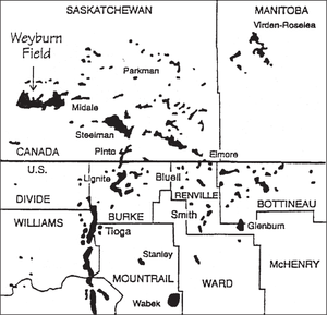
Figure 1 is a map showing the location of Weyburn field.
Weyburn trap problem[edit]

To determine the trap type of Weyburn field, we have to know what forms the lateral closure. It is not structural because dip is homoclinal to the southwest. The field lies southeast of the truncation edge of the Midale Member, where it wedges out beneath Triassic rocks and above older Mississippian rocks. Early workers understood this truncation to be the cause of the trap. Yet there is an area lying downdip from the truncation edge of the Midale and updip from the oil pool in which porous Midale vuggy rocks were present but tested wet with shows of oil.
This raises the possibility that either a stratigraphic change;[3][4][5][6] or hydrodynamics[7][8][9] or perhaps both provide the updip, transverse (lateral) seal. From producing wells at Weyburn and nearby Steelman, the oil column height appears to be 600 ft (183 m). This raises the next question: Could the Midale marly beds provide a seal for a 600-ft oil column, or must hydrodynamics be present to augment the seal quality of the Midale marly beds?
Weyburn structure map[edit]

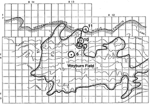
Figure 2 is a structure map of the Weyburn field area, contoured on top of the Mississippian Midale Member. The map also shows the northern erosional limit of the Midale evaporite and the location of the field. Circles indicate cores studied.
Weyburn diagrammatic cross section[edit]
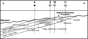
Figure 3 is a diagrammatic dip-oriented cross section of Weyburn field. It shows the truncation of the Midale marly and vuggy beds and the updip facies change in the Midale vuggy beds from a vuggy grainstone to a vuggy mudstone to an anhydrite.
See also[edit]
- Evaluation of trap type
- Midale lithofacies and distribution
- Midale porosity, pore geometries, and petrophysics
- Effect of pore geometry on Sw in midale rocks
- Weyburn seal capacity
- Midale seal capacity and trap type
References[edit]
- ↑ Chetin, A. K., and W. W. Fitkin, 1959, Geology of the Weyburn field, Saskatchewan: Canadian Mining and Metallurgical Bulletin, December, p. 751–761.
- ↑ Coalson, E. B., S. M. Goolsby, and M. H. Franklin, 1994, Subtle seals and fluid-flow barriers in carbonate rocks, in J. C. Dolson, M. L. Hendricks, and W. A. Wescott, eds., Unconformity Related Hydrocarbons in Sedimentary Sequences: RMAG Guidebook for Petroleum Exploration and Exploitation in Clastic and Carbonate Sediments, p. 45–58.
- ↑ 3.0 3.1 Winland, H. D., 1972, Oil accumulation in response to pore size changes, Weyburn field, Saskatchewan: Amoco Production Company Report F72-G-25, 20 p.
- ↑ Winland, H. D., 1976, Evaluation of gas slippage and pore aperture size in carbonate and sandstone reservoirs: Amoco Production Company Report F76-G-5, 25 p.
- ↑ Wegelin, A., 1984, Geology and reservoir properties of the Weyburn field, southeastern Saskatchewan, in J. A. Lorsong and M. A. Wilson, eds., Oil and Gas in Saskatchewan: Saskatchewan Geological Society Special Publication 7, p.71-82.
- ↑ Kent, D. M., F. M. Haidl, and J. A. MacEachern, 1988, Mississippian oil fields in the northern Williston Basin, in S. M. Goolsby, and M. W. Longman, eds., Occurrence and Petrophysical Properties of Carbonate Reservoirs in the Rocky Mountain Region: RMAG Symposium, p. 193–210.
- ↑ Petroleum Research Corporation, 1961, Hydrodynamic exploration for unconformity traps: Research Report A-11, 47 p.
- ↑ Dahlberg, E. C., 1982, Applied hydrodynamics in petroleum exploration: New York, Springer Verlag, 161 p.
- ↑ Hannon, N., 1987, Subsurface water flow patterns in the Canadian sector of the Williston Basin: RMAG 1987 Symposium Guidebook, p. 313–321.
