Llanos basin
| Petroleum Systems Analysis—Case Studies | |

| |
| Series | Memoir |
|---|---|
| Chapter | Fluid Flow Modeling in the Llanos Basin, Colombia |
| Author | Felipe Gonzalez-Penagos, Isabelle Moretti, Xavier Guichet |
| Link | Web page |
| Store | AAPG Store |
Introduction[edit]
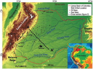
Exploration and production in the Llanos Basin of Colombia (LBC) have proven that this area is a prolific petroleum province (Figure 1). This basin is a foreland with several source rocks in a siliciclastic sequence and numerous hydrocarbon accumulations within various reservoirs. However, fresh water production in well-head rises up to 80% in average and can increase up to 100% quickly after the start of the production for both deep and shallow reservoirs. Uncertainties on this water flow impact the economy of the fields whatever the high success rate of exploration in this area. In addition to this impact on production, the API of the oil is highly variable from low API (around 10°) to rather high ones (up to 45°) (Bautista et al., 2015[1]); if the shallow and low temperature reservoirs such as the ones eastward contain, not surprisingly, heavy oil (such as the Rubiales field; Gómez et al., 2009[2]), some deep reservoirs also contain low API oils.
Due to the low salinity of the produced waters from the hydrocarbon fields, massive recharges of meteoric water have been proposed (Villegas et al., 1994[3]). However, alternative models exist, and the in situ formation of fresh water by shale dehydration has been also proposed (Gonzalez et al., 2011[4]).

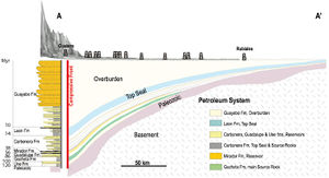
Geochemical data published in previous papers (Gonzalez-Penagos, 2013[5]; Gonzalez-Penagos et al., 2014[6], 2015[7]) showed evidences of mixing of different fluids. Geochemical and isotopic analyses of water show that the single mixing between compaction and meteoric waters cannot explain the data; this discrepancy proves the existence of the third source of water in the basin. To summarize these previous papers, across the foreland flexural profile the geochemical patterns from analytical data of natural gas and formation waters show three main fluid zones: a deep fluid zone accumulated mainly in the foredeep, a shallow fluid zone located in the forebulge, and a transition zone in between. Data from the deep fluid zone suggest that fresh waters, associated to light hydrocarbons, are released from shale dewatering during diagenesis. On the other hand, shallow zone fluid characteristics indicate long-distance hydrocarbon migration and biodegradation as well as a currently active meteoric water flow. The transition zone shows interactions of deep fluid updip migration and meteoric water downdip flow (Figure 2).
If this conceptual model of fluid compartmentalization is in agreement with the geochemical data (hydrocarbon geochemistry, isotopic data of water and of hydrocarbon), a 3-D modeling of the water budget at thebasin scales has never been attempted. A 3-D modeling is the only way to incorporate all the processes described earlier to compare them semi-quantitatively and check the consistency of the model. Basin modeling has been developed to reconstruct the thermicity and the fluid flows over the geological times forpetroleum provinces (Doligez et al., 1986[8]). Even if the fluid flow modeling suffers large uncertainties because of the complex geological distribution of sedimentary units, permeability heterogeneity within a same geological unit, and the diagenetic evolution of the sediments that is difficult to reproduce, an integrated 3-D modeling of the LBC will give new information: (1) relative importance of the processes, (2) timing of the processes, and (3) extrapolation of the processes in undrilled areas.
The primary goal of the full paper associated with this Wiki article is to propose a fluid flow history by a quantification of the main processes (meteoric water inflow, water expelled by the smectite–illite transformation, and maturation and migration of the hydrocarbon). The model is calibrated with various data (temperature, maturation of the source rock, salinity of the formation waters). Even if salinity measurements are easy and done systematically in sedimentary basins, the use of salinity as a geochemical tracer is still limited. Very few studies have addressed the calculation of salinity patterns in 3-D blocks through the geological history of a basin. Recently Gonçalvès et al. (2004[9], 2010[10]) discussed the brine displacement in the Paris Basin and compared the calculated paleosalinity to the measured salinity by microthermometric analyses to constrain the timing of diagenetic events in the deeper parts of the basin. Guichet et al. (2009[11]) discussed the origin and the migration of brine in the North Louisiana Basin and illustrated that the salinity allows constraining the fluid flows in that basin.
Geological Setting[edit]
The LBC is a flat area of about 200,000 km2 (77,220 mi2) between the Eastern Cordillera (westward), the Macarena Range (southward), and the border of Venezuela, which corresponds for a large part to large rivers (Orinoco, Meta, etc.). The LBC is currently the foreland of the Eastern Cordillera, a branch of the Andes. The cross section in Figure 2 shows this west–northwest dipping monocline. Southward, the Macarena Range exposes Cretaceous sequence and separates the LBC of the Putumayo basin, which is the southern foreland of the Colombian Andes.
The crystalline basement of the Llanos is covered by Paleozoic series that consist of siliciclastic Siluro-Devonian deposits; a strong unconformity separates these, locally highly deformed, series from the Mesozoic and Tertiary deposits. The Mesozoic tectonic context was mainly extensive in Colombia, but the depocenter was located westward of the LBC (Villamil, 1999[12]). The Lower Cretaceous series, known in the Eastern Cordillera (Campos Alvarez et al., 2007[13]), are restricted to the western side of the Guaicaramo fault and are so absent in the Llanos foreland. In the west of Colombia the compression that leads to the Andes formation began during the Cretaceous times; the first accretion started during the Aptian, whereas subsidence continued eastward with the deposition of the Une, Gacheta, and Guadalupe formations in the Llanos (Sarmiento, 2001[14]). Subsequent accretion took place westward at the end of the Maastrichtian, resulting in the beginning of uplift of the Central Cordillera and the first inversion in the now Magdalena Valley (Casero et al., 1997; Sarmiento, 2001). In the Llanos, subsidence continued in a very poorly deformed basin during the Paleocene, with the deposition of the Barco, Los Cuervos, and Mirador formations (Cooper et al., 1995[15]; Bayona et al., 2008[16]; Reyes-Harker et al., 2015[17]). A compressive context predominates in the Eastern Cordillera since the Eocene. After the inversions of the Mesozoic extensional grabens, a thrust regime developed, and the Llanos Orientales became a classical, but rather external, foreland during the deposition of the Carbonera and Leon formations (Moretti et al., 2009[18]; Mora et al., 2015[19]). The Eastern Cordillera is a double verging mountain belt: the western flank in the Magdalena Valley was initially the more active one but the active compressive front has now shifted to the Llanos where the Miocene foreland is currently affected by the compression that propagates eastward. The structure that corresponds to the former Early Cretaceous basin edge is the Guaicaramo fault (Bayona et al., 2008[16]), but some thrusts and blind thrusts exist eastward of it (called compressive front in the figures).
The lithological column of the area is presented Figure 2 with a cross section that shows the pinchout of the various series toward the east and the sand–shale alternating sequences.
A regional fault system oriented mainly northeast–southwest is defined based on the seismic interpretations, and previously published works show that the faults have been reactivated as normal and strike slip faults during the whole Tertiary (Moretti et al., 2009[18]). The inversion structures are only visible westward near the Eastern Cordillera front, and the Leon shale appears to be an efficient disharmonic level. These faults, despite their rather limited offsets, play an important role as lateral barrier in the fluid flow history and have to be taken into account in any migration and accumulation modeling. The majority of the traps in the LBC are structural; they are bordered and closed eastward by these small offset east dipping normal faults, which are considered as seal based on the exploration results. Stratigraphic traps also exist, mainly eastward.
Petroleum System[edit]
The LBC is a prolific hydrocarbon province that produces about 70% of Colombian oil and focuses high expectations in exploration, especially for heavy oil. Water in this petroleum system plays an important role: as already noted, about 80% of the total produced fluids, even in the deepest northern area, are not hydrocarbon but fresh water.
Numerous studies of the petroleum system have been published; they allow us having a good knowledge of the foreland geometry and temperature evolution through time. The precise analysis of hydrocarbon charge in the LCB is out of the scope of this study but since water and hydrocarbons are migrating together in the foreland, the main features of this system in terms of fluid circulation have to be summarized. More details could be found in Villegas et al. (1994[3]), Moretti et al. (2009[20]), Mora et al. (2010[21]), Person et al. (2012[22]), and Vayssaire et al. (2013[23]).
The source rocks, not only Cretaceous but also Tertiary in age, are only mature westward near the Eastern Cordillera thrust front. Source rock maturation started at the Miocene (Moretti et al., 2009[20]; Vayssaire et al., 2013[23]). However, the true deepening of the basin is recent and mainly due to the molasses (Guayabo Formation) deposits. During the past 10 m.y. the increase in burial and so maturation and expulsion of hydrocarbons resulted in a currently very active petroleum system. Hydrocarbons are migrating eastward in the different carrier beds and are trapped in structural and stratigraphic plays. Except in the narrow foothills ring where the structures are thrust anticlines, the structural traps consist mainly in the crest of faulted blocks bordered by east dipping normal faults. The stratigraphic prospects are either the channel of the Carbonera Formation or the pinch out of the sandy series eastward.
Eastward the reservoirs are shallow, and so at temperatures lower than 80°C (176°F), biodegradation occurs, resulting in heavy oil reserves. Westward the first flow of hydrocarbons reached shallow reservoirs and has also been biodegraded, but the current charge of hydrocarbons that refreshes these reservoirs may consist of high API light oils (Dzou et al., 1999[24]; Ramón et al., 2001[25]). An alternative interpretation of these data has been proposed recently: the mixture between low-gravity and high-gravity hydrocarbons in the western field could also be due to the mélange between a first charge of only early-mature hydrocarbon and a more recent charge pulse of late-mature hydrocarbon (Gonzalez-Penagos et al., 2015[7]). In addition to the fact that there are numerous source rocks, this mixture of different oil at different maturity levels makes it difficult to predict the characteristics of the hydrocarbons (Figure 2).
In addition to these west–east variations, the basin shows a north–south difference; the Carbonera formations are thicker in the south, whereas the Guayabo Formation is up to 6 km (3.7 mi) thick in the north and only 3 km (1.9 mi) thick in the south. As a result, maturation started during the middle Miocene in the south and only recently in the north (Moretti et al., 2009[20]; Vayssaire et al., 2013[23]).
See also[edit]
References[edit]
- ↑ Bautista, D., E. Vaz dos santos Neto, and H. de B. Penteado, 2015, Control son Petroleum composition of the Llanos Basin, Colombia: Implication for explorations: AAPG Bulletin], v. 99, no. 8, p. 1503–1536.
- ↑ Gómez, Y., F. Yoris, J. Rodriguez, F. Portillo, and Y. Araujo, 2009, Aspectos Hidrodinámicos, Estructurales Y Estratigráficos Del Campo Rubiales. Cuenca De Los Llanos Orientales, Colombia, In X Simposio Bolivariano Exploración Petrolera en Cuencas Subandinas, Cartagena, Conference Proceedings.
- ↑ 3.0 3.1 Villegas, M., S. Bachu, J. C. Ramon, and J. Underschultz, 1994, Flow of formation waters in the Cretaceous-Miocene succession of the Llanos Basin, Colombia: AAPG Bulletin, v. 12, p. 1843–1862.
- ↑ Gonzalez, F., I. Moretti, and X. Guichet, 2011, Formation water flow and diagenesis in the Colombian Llanos foreland basin: First Break, v. 29, p. 51–58, DOI: 10.3997/1365-2397.2011029.
- ↑ Gonzalez-Penagos, F., 2013, Origins and sources of formation water and natural gas in a Foreland Basin, geochemical distribution and 3D modelling of the fluid flow history: Llanos Basin of Colombia case study: Ph.D. thesis, Université Pierre et Marie Curie (UPMC) Paris, 182 p.
- ↑ Gonzalez-Penagos, F., I. Moretti, C. France Lanord, and X. Guichet, 2014, Origins of formation waters in the Llanos forland basin of Colombia: geochemical variation and fluid flow history: Geofluids, v.14(4), p. 443–458, DOI: 10.1111/gfl.12086.
- ↑ 7.0 7.1 Gonzalez-Penagos, F., V. Rouchon, X. Guichet, and I. Moretti, 2015, The distribution of thermogenic, bacterial and inorganic fluid sources in the petroleum systems of the Llanos Basin (Colombia) – Insights from the noble gases and carbon stable isotopes: Marine and Petroleum Geology, v. 71, p. 391–403.
- ↑ Doligez, B., F. Bessis, J. Burrus, Ph. Ungerer, and P. Y. Chenet, 1986, Integrated numerical simulation of sedimentation, heat transfer, hydrocarbon formation and fluid migration in a sedimentary basin: The Temis Model. In Thermal Modeling in Sedimentary Basins, Proceeding of the 1st IFP Research Conference on Exploration, Carcans, June 3–7, 1985, p. 173–195.
- ↑ Gonçalvès, J., S. Violette, F. Guillocheau, C. Robin, M. Pagel, D. Bruel, et al., 2004, Contribution of a three-dimensional regional scale basin model to the study of the past fluid flow evolution and the present hydrology of the Paris basin, France: Basin Research, v. 16, no. 4, p. 569–586.
- ↑ Gonçalvès, J., M. Pagel, S. Violette, F. Guillocheau, and C. Robin, 2010, Fluid inclusions as constraints in a three-dimensional hydro-thermo-mechanical model of the Paris basin, France: Basin Research, v. 22, no. 5, p. 699–716.
- ↑ Guichet, X., S. Wolf, and P. Pandi, 2009, Paleo-fluid flows and present hydrodynamic conditions improved by Basin modeling integrating Salinity Transport, AAPG International Conference, Rio de Janeiro, Brazil, November 15–18, accessed January 5, 2017, http://www.searchanddiscovery.com/abstracts/html/2009/intl/abstracts/guichet.htm.
- ↑ Villamil, T., 1999, Campanian-Miocene tectonostratigraphy, depocenter evolution and basin development of Colombia and western Venezuela: Palaeogeography, Palaeoclimatology, Palaeoecology, v. 153, no. 1–4, p. 239–275, DOI: 10.1016/S0031-0182(99)00075-9.
- ↑ Campos Alvarez, N. O., and B. P. Roser, 2007, Geochemistry of black shales from the Lower Cretaceous Paja Formation, Eastern Cordillera, Colombia: Source weathering, provenance, and tectonic setting: Journal of South American Earth Sciences, v. 23, p. 271–289.
- ↑ Sarmiento, L. F., 2001, Mesozoic rifting and Cenozoic basin inversion history of the Eastern Cordillera, Colombian Andes. Inferences from tectonic models: Ph.D. Thesis Vrije Universiteit, Amsterdam, The Netherlands, 297 p.
- ↑ Cooper, M. A., F. T. Addison, R. Alvarez, A. B. Hayward, S. Howe, A. J. Pulham, et al., 1995, Basin development and tectonic history of the Llanos Basin, Colombia], in Petroleum Basins of South America: AAPG Memoir 62, p. 659–665.
- ↑ 16.0 16.1 Bayona, G., M. Cortés, C. Jaramillo, G. Ojeda, J. J. Aristizabal, and A. Reyes-Harker, 2008, An integrated analysis of an orogen–sedimentary basin pair: Latest Cretaceous–Cenozoic evolution of the linked Eastern Cordillera orogen and the Llanos foreland basin of Colombia: GSA Bulletin, v. 120, no. 9/10, p. 1171–1197.
- ↑ Reyes-Harker, A., C. F. Ruiz-Valdivieso, A. Mora, J. C. Ramirez-Arias, G. Rodriguez, F. de la Parra, et al., 2015, Cenozoic paleogeography of the Andean Foreland and retroact hinterland of Colombia: AAPG Bulletin, v. 99, no. 8, p. 1407–1454, DOI: 10.1306/06181411110.
- ↑ 18.0 18.1 Moretti, I., J. C. Mondragon, J. C. Garzon, G. Bosio, and J. M. Daniel, 2009a, Structural style and decollement levels in the Llanos Orientales Basin (Colombia). X Congress Bolivariano, Conference Proceedings.
- ↑ Mora, A., W. Casallas, R. Ketcham, D. Gomez, M. Parra, J. Manson, et al., 2015, Kinematic restoration of contractional basement structures using thermokinematic models: A key tool for petroleum system modeling: AAPG Bulletin], v. 99, no. 8, p. 1575–1598, DOI: 10.1306/04281411108.
- ↑ 20.0 20.1 20.2 Moretti, I., C. Mora, W. Zamora, M. Valendia, G. Rodriguez, and M. Mayorga, 2009b, Petroleum system variations in the Llanos Basin (Colombia). X Congress Bolivariano, Conference Proceedings.
- ↑ Mora, A., B. K. Horton, A. Mesa, J. Rubiano, R. A. Ketcham, M. Parra, et al., 2010, Migration of Cenozoic deformation in the Eastern Cordillera of Colombia interpreted from fission track results and structural relationships: Implications for petroleum systems: AAPG Bulletin, v. 91, no. 10, p. 1543–1580.
- ↑ Person, M., D. Butler, C. W. Gable, T. Villamil, D. Wavrek, and D. Schelling, 2012, Hydrodynamic stagnation zones: A new play concept for the Llanos Basin, Colombia: AAPG Bulletin, v. 96, no. 1, p. 23–41, DOI: 10.1306/08101111019.
- ↑ 23.0 23.1 23.2 Vayssaire, A., H. Abdallah, W. Hermoza, and E. Figari Negri, 2013, Regional study and petroleum system modeling of the Eastern Llanos, Search and Discovery Article 10564, accessed May 31, 2017, http://www.searchanddiscovery.com/pdfz/documents/2014/10564vayssaire/ndx_vayssaire.pdf.html.
- ↑ Dzou, L. I., A. G. Holba, J. C. Ramón, J. M. Moldowan, and D. Zinniker, 1999, Application of new diterpane biomarkers to source, biodegradation and mixing effects on Central Llanos Basin oils, Colombia: Organic Geochemistry, v. 30, no. 7, p. 515–534, DOI: 10.1016/S0146-6380(99)00039-X.
- ↑ Ramón, J. C., L. I. Dzou, W. B. Hughes, and A. G. Holba, 2001, Evolution of the Cretaceous organic facies in Colombia: Implications for oil composition: Journal of South American Earth Sciences, v. 14, no. 1, p. 31–50, DOI: 10.1016/S0895-9811(01)00010-4.
