South Viking Graben
| Rift-Related Coarse-Grained Submarine Fan Reservoirs: The Brae Play, South Viking Graben, North Sea | |
| |
| Series | Memoir |
|---|---|
| Chapter | The South Viking Graben: Overview of Upper Jurassic Rift Geometry, Biostratigraphy, and Extent of Brae Play Submarine Fan Systems |
| Author | Colin C. Turner, Bryan T. Cronin, Leslie A. Riley, Stefano Patruno, William T. L. R. Reid, Silvan Hoth, Dirk Knaust, Simon Allerton, Mark A. Jones, Christopher A.-L. Jackson |
| Link | Web page |
| Store | AAPG Store |
Introduction[edit]
The South Viking Graben (SVG), in the northern part of the North Sea, is a well-studied Middle to Upper Jurassic rift basin containing a major hydrocarbon province that extends across the border between the United Kingdom and Norway. Thermal doming during the Toarcian–Aalenian, centered on the area south of the southern end of the SVG, resulted in the deposition of thick Middle Jurassic sequences along a north-trending basin that is now the SVG (Underhill and Partington, 1993[1]; and see Hoth et al., 2018[2]). Subsequent deflation of the dome was followed by significant rifting in the SVG, which began in the Callovian. However, the most active phases of rifting occurred during the Oxfordian to early Volgian (early Tithonian), when very thick synrift sequences were deposited in the graben. The graben is bounded on the west by the Fladen Ground Spur (FGS) and on the east by the Utsira High (Figure 1). A large proportion of the hydrocarbon reserves is found in synrift to early postrift, deep-marine clastic sediments of the Brae Formation; these accumulations are informally termed the Brae Play. The Brae Formation interfingers with, and is overlain by, the Kimmeridge Clay Formation (KCF; termed Draupne Formation in Norway). The KCF-Draupne Formation is the major source rock and is the most significant seal for trapped Brae Play hydrocarbons. Several previous publications have shown the outlines and general internal structure of this buried half-graben (e.g., Harris and Fowler, 1987[3]; Johnson et al., 1993[4]; Sneider et al., 1995[5]; Thomas and Coward, 1996[6]; Fraser et al., 2003[7]; Zanella and Coward, 2003[8]) and numerous papers have dealt with various other aspects of the graben (see Connell, 2018[9], for a full reference list). However, more accurate depictions of the structure, particularly the western fault-bounded margin and the internal structure of the graben fill, are now possible due to the complete coverage of the area by high-quality 3-D seismic data. A 3-D image of the south and central parts of the Viking Graben and its flanks, at Base Cretaceous level, is shown in Figure 2. In addition, extensive released well-data sets are available in this mature hydrocarbon province that allow comprehensive analysis of the stratigraphy and a clearer understanding of the extent of submarine fans containing hydrocarbon reservoirs.
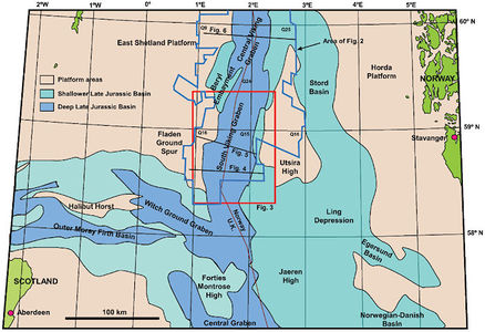
Figure 1 Location of the South Viking Graben (SVG) (simplified from Fraser et al., 2003[7]). Note that both the U.K. and Norway areas are divided into 1° x 1° Quadrants (numbered on map around the SVG), with each quadrant being subdivided into blocks; in the U.K., 30 blocks are designated in each quadrant, whereas in Norway, 12 blocks are defined, as shown on Figure 3. Areas of Figure 2 and Figure 3 and locations of Figure 4, Figure 5, and Figure 6 are also shown.
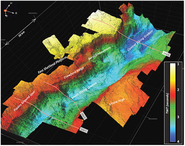
Figure 2 3-D structural image of the South Viking Graben and southern part of the Central Viking Graben at Base Cretaceous level, viewed from the southeast. Location of image shown in Figure 1. Lines 1–3 are the locations of seismic lines in Figure 4, Figure 5, and Figure 6, respectively. Courtesy of PGS.


Rift geometry and geographic limits[edit]
The SVG has a half-graben geometry, with the graben-bounding fault system on the western side being far more pronounced than the boundary on its eastern margin (Figure 2, Figure 3, Figure 4, Figure 5). The wider structural context of the SVG is shown in Zanella and Coward (2003[8], their figure 4.11) and high-quality seismic images of parts of the western margin of the graben and the platform area to the west are shown in Patruno and Reid (2016[11], 2017[12]). To the south of the North Brae field, the western graben margin trends north-south, and to the north of the Braemar field it trends north-northeast–south-southwest (Figure 3). Between the North Brae and East Brae fields, the graben margin trends northeast–southwest, probably following a Caledonian lineament, and skirts an area of Silurian granite (drilled at the Cairngorm discovery—well U.K. 16/3a-11) at the edge of the footwall (the FGS). Between East Brae and Braemar the graben margin trends to the north-northwest, following the interpreted edge of this granite body, which is assumed to intrude early Paleozoic basement rocks (undrilled in this area). Thick Devonian sandstones overlying these older rocks are present across much of the FGS (Patruno and Reid, 2016[11], 2017[12]; Patruno et al., 2018[13]). The major fault zone on the western side of the SVG can be defined by three significant lineaments;
the erosional eastern edge of sub-Upper Jurassic rocks that comprise the FGS,
the abutment of the Top KCF (early Ryazanian) against the fault plane or eroded fault scarp (although thin units of KCF occur in places on the FGS—Figure 3), and
the abutment of the (prerift) Top Sleipner Formation (approximately Top Bathonian) against the eastward-dipping graben-margin fault plane (Figure 3, Figure 4, Figure 5).
The area between the edge of the FGS and the abutment of the KCF is in most parts an eroded slope, against which Cretaceous units onlap (Figure 4). The dip of this slope is about 30–35 degrees, calculated from well penetrations at the top and near the base of the slope. This slope extends a short distance basinward beneath the upper part of the Kimmeridge Clay before grading into the noneroded fault scarp, which has a dip of approximately 60 degrees (estimated from seismic mapping and depth conversion). The total amount of original throw on the western boundary fault is more difficult to estimate due to the erosion on the FGS. The depth of the pre-Upper Jurassic “basement” on the FGS along the edge of the graben is generally between 7750 and 9000 ft (∼2360–2740 m). The deepest parts of the synrift section along the western margin of the graben, represented by the top of the Bathonian Sleipner Formation, lie at approximately 20,000 to 23,000 ft (∼6100–7000 m) in the area shown in Figure 3, implying a minimum throw of 12,000 to 14,000 ft (∼3660–4270 m). However, the total throw on the western boundary fault may have been considerably larger than this difference between these two depth ranges, due to the unknown thicknesses of strata eroded from the FGS during the Late Jurassic. It is probable that at least some Middle Jurassic to Permian sequences overlying Devonian and older rocks (there were probably only minor amounts, if any, of Carboniferous rocks in the area) were originally present on the FGS prior to late Jurassic rifting
If the thickness of Permian to Middle Jurassic in the graben were known, this could be used to estimate the maximum total throw by assuming that a similar thickness may have been present on the FGS (although the thickness is likely to have been less on the FGS as the fault was probably active during parts of this time period). The depth of the pre-Permian section (presumably Top Devonian or older rocks) within the graben, adjacent to the fault plane, is generally too deep to be imaged consistently by seismic data, but is probably in excess of 30,000 ft (∼9140 m) along much of this margin, implying (by comparison with the Top Bathonian depths) a thickness of Permian to Middle Jurassic strata at the graben margin of 7000 to 10,000 ft (2130–3050 m). If a similar thickness of Permian to Middle Jurassic strata existed on the FGS prior to late Jurassic rifting, then the total maximum throw on the western boundary fault can be estimated as 19,000–24,000 ft (∼5790–7310 m).
The difference between these minimum and maximum estimates for late Jurassic throw on the western margin of the SVG is considerable and reflects the continued uncertainty of the post-Variscan, pre-late Jurassic history of the FGS area. From considerations of the thicknesses of Permian to Triassic sequences farther to the north, Turner and Connell (2018[14]) estimate that several thousand feet (several hundred meters) of Permian to Middle Jurassic strata may have been eroded from the FGS in the Brae area. However, Patruno and Reid (2017[12]) consider that there may have been only minor amounts of such strata present prior to late Jurassic erosion. These differences in interpretation result mainly from whether existing fault-bounded Permo-Triassic successions on the FGS are regarded as having been deposited in active grabens with only minor deposition beyond the present basin limits (e.g., Patruno and Reid, 2017[12]), or whether they are interpreted as remnants of much more widespread deposits (albeit probably in part syn-tectonic) that were downfaulted during the Jurassic (as implied by Turner and Connell, 2018[14]).

To the south of approximately 59°N, the base of the synrift fill rises eastward in a series of fault terraces toward the Utsira High (Figure 4, Figure 5) where Devonian and older rocks are present beneath a thinCretaceous (and in places Jurassic) sequence. Between approximately 59°N and 59° 30’N, the deepest part of the graben is somewhat more symmetrical, with a large fault defining its eastern boundary as well as its western boundary but with the western margin also stepping back westward to include the Beryl embayment. Farther north still, in the Central Viking Graben, it reverts to true half-graben geometry (Figure 2, Figure 6). The eastern margin of the southern part of the SVG is, therefore, less precisely defined than its western margin. The thickest section of Upper Jurassic strata in the graben is bounded by several down-to-the-west normal faults (Figure 3), but the true eastern margin of the graben is difficult to define as flexural downbending was the dominant mechanism here, rather than faulting. An approximation of the easterly limit of the late Jurassic graben can be taken at the eastern termination of seismically-definitive Top KCF-Draupne Formation (Figure 3). However, the uppermost KCF-Draupne Formation was deposited after rifting had ceased and extends in places beyond the original graben limits. Although some areas of the Utsira High are devoid ofDraupne Formation (Figure 3), relatively thin units (generally <100 m [∼330 ft]) of Draupne Formation are present on parts of the high, particularly on its eastern flank, where it deepens toward the Stord Basin and southward toward the Jaeren High. Thin (<40 m [∼130 ft]) intra-Draupne sandstones also occur on the eastern flank of the high, notably forming the main reservoir of the extensive Johan Sverdrup field (Scott and Ottesen, 2018[15]). An area of KCF, in part overlying thin Upper Jurassic shallow-marine sandstones, also occurs on the FGS to the west of the Brae fields (Figure 3).
To the north, there is no precise definition of the limit of the SVG. Most previous publications have used a threefold subdivision of the entire graben into South, Central, and North (e.g., Zanella and Coward, 2003[8]). The boundary between the South and Central Viking Graben, although somewhat arbitrary, can be conveniently taken toward the north end of the Crawford Ridge (approximately 59° 30’N). Here, the graben widens significantly to include the Beryl embayment, which is regarded as part of the Central Viking Graben (Figure 2). On the western flank of the Central Viking Graben, the footwall is at a shallower depth than the FGS farther south and the Base Cretaceous within the graben is significantly deeper than farther south (Figure 2, Figure 6).
At the southern end of the SVG, the FGS becomes narrower, its top becomes progressively deeper, the major western graben boundary fault becomes less distinct south of Block 16/17, and the graben merges with the eastern part of the Witch Ground Graben and the northern part of the Central Graben (Figure 1). The southeastern margin of the graben is also difficult to define precisely as the Utsira High becomes deeper southward and at least thin units of Upper Jurassic strata extend across this area (Figure 3).
Within the SVG the location of the thickest sequence of Upper Jurassic strata generally corresponds with the deepest axis of the graben, defined at base Upper Jurassic level, close to the western margin (Figure 3, Figure 4, Figure 5). Several sub-basins (Vana, Vilje, and Ve; see www.npd.no) can be identified, partially separated by northwest–southeast orientated intragraben faults that probably follow deeper crustal features along the Tornquist structural trend (Figure 3).
Stratigraphic units and structural elements[edit]
Three major Jurassic-Cretaceous stratigraphic elements are present within the SVG; a Bathonian and older prerift sequence, a Callovian to Upper Jurassic synrift sequence (referred to later for convenience as Late Jurassic in age) and a postrift uppermost Jurassic to Cretaceous sequence. The recent broadband 3-D seismic data shot across the entire width of the South and Central Viking Graben (Figure 4, Figure 5) have provided significant improvements to the imaging of these sequences compared with previous surveys. Figure 4B and Figure 5B provide structural interpretations of these intervals and various faults within the graben, from which some general conclusions can be drawn.
See also[edit]
References[edit]
- ↑ Underhill, J. R., and M. A. Partington, 1993, Jurassic thermal doming and deflation in the North Sea: Implications of the sequence stratigraphic evidence, in J. R. Parker, ed., Petroleum Geology of Northwest Europe: Proceedings of the 4th Conference: Geological Society (London) Conference Series 4, p. 337–345.
- ↑ Hoth, S., D. Knaust, A. Sánchez-López, S. Kassold, and S. Sviland-Østre, 2018, The Gudrun field: Gravity-flow deposition during rifting and inversion], in C. C. Turner, and B. T. Cronin, eds., Rift-related coarse-grained submarine fan reservoirs; the Brae Play, South Viking Graben, North Sea: AAPG Memoir 115, p. 387–422.
- ↑ Harris, J. P., and R. M. Fowler, 1987, Enhanced prospectivity of the Mid-Late Jurassic sediments of the South Viking Graben, northern North Sea, in J. Brooks and K. Glennie, eds., Petroleum Geology of North West Europe: Bath, U.K., Graham and Trotman, p. 879–898.
- ↑ Johnson, H., P. C. Richards, D. Long, and C. C. Graham, 1993, United Kingdom offshore regional report; the geology of the northern North Sea: London, HMSO, for the British Geological Survey.
- ↑ Sneider, J. S., P. de Clarens, and P. R. Vail, 1995, Sequence stratigraphy of the Middle to Upper Jurassic, Viking Graben, North Sea, in R. J. Steel, V. L. Felt, E. P. Johannessen, and C. Mathieu, eds., Sequence stratigraphy on the Northwest European margin: Norwegian Petroleum Society Special Publication 5, p. 167–197.
- ↑ Thomas, D. W., and M. P. Coward, 1996, Mesozoic regional tectonics and South Viking Graben formation: Evidence for localized thin-skinned detachments during rift development and inversion: Marine and Petroleum Geology, v. 13, p. 149–177.
- ↑ 7.0 7.1 Fraser, S., A. M. Robinson, H. D. Johnson, J. R. Underbill, D. G. A. Kadolsky, R. Connell, P. Johannessen, and R. Ravnås, 2003, Upper Jurassic, in D. Evans, C. Graham, A. Armour, and P. Bathurst, eds., The millennium atlas: Petroleum geology of the central and northern North Sea: Geological Society (London), p. 157–189.
- ↑ 8.0 8.1 8.2 Zanella, E., and M. P. Coward, 2003, Structural framework, in D. Evans, C. Graham, A. Armour, and P. Bathurst, eds., The Millennium Atlas: Petroleum geology of the central and northern North Sea: Geological Society (London), p. 45–59.
- ↑ Connell, E. R., 2018, Bibliography of geological publications and Ph.D. theses from the South Viking Graben area, North Sea, in C. C. Turner, and B. T. Cronin, eds., Rift-related coarse-grained submarine fan reservoirs; the Brae Play, South Viking Graben, North Sea: AAPG Memoir 115, p. 619–628.
- ↑ Zanella, E., M. P. Coward, and A. McGrandle, 2003, Crustal structure, in D. Evans, C. Graham, A. Armour, and P. Bathurst, eds., The millennium atlas: Petroleum geology of the central and northern North Sea: Geological Society (London), p. 35–43.
- ↑ 11.0 11.1 Patruno, S., and W. Reid, 2016, New plays on the Greater East Shetland Platform (UKCS Quadrants 3, 8–9, 14–16)—part 1: Regional setting and a working petroleum system: First Break, v. 34, p. 33–45.
- ↑ 12.0 12.1 12.2 12.3 Patruno, S., and W. Reid, 2017, New plays on the Greater East Shetland Platform (UKCS Quadrants 3, 8–9, 14–16)—part 2: Newly reported Permo-Triassic intra-platform basins and their influence on the Devonian-Paleogene prospectivity of the area: First Break, v. 35, p. 59–69.
- ↑ Patruno, S., W. Reid, C. Berndt, and L. Feuilleaubois, in press, Polyphase tectonic inversion and its role in controlling hydrocarbon prospectivity in the Greater East Shetland Platform and Mid North Sea High, UK, in A. A. Monaghan, J. R. Underhill, A. J. Hewett, and J. E. A. Marshall, eds., Paleozoic plays of NW Europe: Geological Society (London) Special Publication 471, doi:10.1144/SP471.9.
- ↑ 14.0 14.1 Turner, C. C., and E. R. Connell, 2018, Mid to Late Jurassic graben margin development and evolution of shallow marine to submarine fan systems in the Brae area of the South Viking Graben, U.K. North Sea, in C. C. Turner, and B. T. Cronin, eds., Rift-related coarse-grained submarine fan reservoirs; the Brae Play, South Viking Graben, North Sea: AAPG Memoir 115, p. 163–212.
- ↑ Scott, A. S. J., and S. Ottesen, 2018, Tectono-stratigraphic development of the Upper Jurassic in the Johan Sverdrup area, in C. C. Turner, and B. T. Cronin, eds., Rift-related coarse-grained submarine fan reservoirs; the Brae Play, South Viking Graben, North Sea: AAPG Memoir 115, p. 445–452.
External links[edit]
| find literature about South Viking Graben |