Search results
Jump to navigation
Jump to search
Page title matches
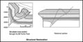
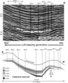
- ...ent uplift; WF = Waterpocket fold; A = Absaroka thrust fault. (c) Covenant field locality map of central Utah. From Parry, et. al<ref name=Parry />]] ...hitecture, petroleum systems, and geological implications for the Covenant field discovery, Sevier County, Utah]: AAPG Search and Discovery Article No. 11006 KB (897 words) - 19:39, 14 February 2017
- | title = Pinedale Field: Case Study of a Giant Tight Gas Sandstone Reservoir | chapter = The Significance of the Pinedale Field16 KB (2,521 words) - 17:13, 29 January 2016
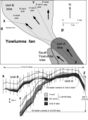
- ...turbidite reservoir: The ARCO-DOE 91X-3 horizontal well project, Yowlumne field, San Juaquin Basin, California Yowlumne is a giant oil field in the San Joaquin Basin, California ([[:file:Mth14ch02f01.jpg|Figure 1]]),13 KB (1,896 words) - 19:02, 11 March 2019
- ...cuna 3-D seismic survey ([[:File:Methods14ch08f01.jpg|Figure 1]]), Arecuna field contains an estimated 2.8 billion barrels of original oil in place, but to ==Geologic architecture of the Arecuna field==16 KB (2,381 words) - 19:03, 11 March 2019
- ...Reservoir Geology of the Upper Jurassic Brae Sandstone Member, Kingfisher Field, South Viking Graben, U.K. North Sea ...55–62.</ref><ref name=Fletcher2003b>Fletcher, K. J., 2003b, The South Brae Field, Blocks 16/07a, 16/07b, UK North Sea, in J. G. Gluyas and H. M. Hichens, ed16 KB (2,358 words) - 16:28, 11 January 2024
- | chapter = A Depositional Model for the T-Block Thelma Field, UKCS Block 16/17 ...form. A total of seven producers have been drilled across the whole Thelma field area ([[:file:M115CH11FG02.jpg|Figure 2]]), with four wells dominating prod17 KB (2,614 words) - 19:14, 17 January 2022
- Wattenberg field | chapter = Field Growth in the Supergiant Wattenberg Field, Denver Basin, Colorado, USA72 KB (10,249 words) - 20:06, 15 January 2024
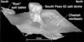
- ...nd conclusions of a horizontal-drilling program at South Pass 62 salt-dome field Prudhoe Bay field lies on the Alaska coastal plain between Naval Petroleum Reserve No. 4 (NPR11 KB (1,634 words) - 16:34, 26 April 2016
- 3 KB (412 words) - 22:40, 1 February 2022
- ...nd conclusions of a horizontal-drilling program at South Pass 62 salt-dome field ....jpg|Figure 2]], [[:file:Mth14ch04f03.jpg|Figure 3]]). A 3-D seismic-based field study completed in 1994 identified reservoir targets for the horizontal-dri9 KB (1,290 words) - 21:18, 19 October 2016

File:Oil-field-production-geology.png (450 × 633 (553 KB)) - 18:24, 7 April 2014- #REDIRECT [[Magnetic field: local variations]]46 bytes (5 words) - 21:19, 14 May 2014
- Variations in the local magnetic field are due mainly to the following: ...urves above the cross section are the magnetic profiles where the magnetic field is vertical for ''k''<sub>1</sub> > ''k''<sub>2</sub> and ''k''<sub>1</sub>6 KB (946 words) - 19:56, 27 January 2022
- ...ter contacts and apparent anomalies in saturation profiles in the Sorrento field are due to multiple flow units from two separate reservoirs. This example u ...as Fields, p. 305–328.</ref> Reliably recognizing separate reservoirs in a field requires considering [[capillary pressure]]s, [[Free water level|heights ab7 KB (1,044 words) - 16:57, 13 April 2022
- ...ts and not necessarily in response to structural [[dip]]. Gas in the Beryl field, for example, migrated downdip during production in response to changing pr ==Fault seal and field unitization==3 KB (479 words) - 15:21, 30 March 2022
- #REDIRECT [[Sorrento field: water saturation]]46 bytes (5 words) - 16:15, 21 November 2014
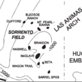
- ...., and E. B. Coalson, 1990, Evaluation of the Morrow sandstone in Sorrento field, Cheyenne County, Colorado, ''in'' S. A. Sonnenberg, L. T. Shannon, K. Rade * [[Setting and structure of the Sorrento field]]7 KB (956 words) - 17:24, 11 April 2022
- ...name=ch09r9>Chetin, A. K., and W. W. Fitkin, 1959, Geology of the Weyburn field, Saskatchewan: Canadian Mining and Metallurgical Bulletin, December, p. 751 ...erformance_fig9-96.png|Figure 1]] is a map showing the location of Weyburn field.6 KB (848 words) - 17:34, 3 January 2024
- #REDIRECT [[Sorrento field: water saturation]]46 bytes (5 words) - 16:16, 21 November 2014
- #REDIRECT [[Sediment thickness and field location maps: Gulf of Mexico example]]80 bytes (11 words) - 21:04, 19 December 2014
- ...Tectonic and sedimentation model for Morrow sandstone deposition, Sorrento field area, Denver basin, Colorado: The Mountain Geologist, October, p. 180-191.< ...-and-performance_fig9-85.png|Figure 1]] shows the location of the Sorrento field. Structure is contoured on the base of the Pennsylvanian.3 KB (429 words) - 14:19, 11 April 2022
- ...Tectonic and sedimentation model for Morrow sandstone deposition, Sorrento field area, Denver basin, Colorado: The Mountain Geologist, October, p. 180-191.< Morrow sandstones in the Sorrento field are slightly shaly, range in [[grain size]] from very coarse to fine, and a6 KB (769 words) - 17:23, 11 April 2022
- 5 KB (753 words) - 19:58, 18 February 2022
- Planning and logistics are key components for the success of any field party. An important pre-field step is to review previous work. This includes finding and evaluating previ5 KB (730 words) - 22:36, 1 February 2022

Page text matches
File:MainPageSorrentoField.png ...: Sorrento field; Petrophysical analysis of Sorrento field wells; Sorrento field: water saturation.(400 × 400 (43 KB)) - 17:53, 5 January 2015
File:BasinCenteredGasFig4.jpg ...Relief on top of overpressuring from outside the field area to inside the field area ranges from 2500 to 3000 ft (762-914 m) (Warner, 1998). Figure modifie(600 × 783 (79 KB)) - 22:22, 13 January 2015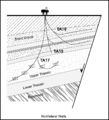
File:M91Figure165.JPG ...printed with permission from the Geological Society in AAPG Memoir 91, Oil field petroleum geology, by Mike Shepherd.(800 × 881 (128 KB)) - 20:28, 30 July 2014- | image = Oil-field-production-geology.png | title = Oil Field Production Geology1 member (0 subcategories, 0 files) - 17:33, 13 April 2022
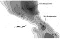
File:M115CH10FG03.jpg ...ingfisher field 15 km (9 mi) to the northeast. Modified after [[Kingfisher field|Turner et al. (1987]]). From AAPG Memoir 115—Rift-Related Coarse-Grained(1,076 × 597 (435 KB)) - 18:42, 17 January 2019
File:M91Ch6FG42.JPG ...slow, 1999). From Shepherd, M., 2009, Sources of data, in M. Shepherd, Oil field production geology: AAPG Memoir 91, p. 49-63.(800 × 942 (95 KB)) - 17:04, 3 June 2015
File:M91Ch6FG47.JPG ...cal Society. From Shepherd, M., 2009, Sources of data, in M. Shepherd, Oil field production geology: AAPG Memoir 91, p. 49-63.(600 × 758 (111 KB)) - 21:46, 29 April 2015
File:M91Figure164.JPG ...h et al., 1998). Reprinted with permission from the AAPG in Memoir 91, Oil field petroleum geology, by Mike Shepherd.(800 × 483 (64 KB)) - 20:19, 30 July 2014
File:M91FG188.JPG ...amma ray. From Shepherd, M., 2009, Deltaic reservoirs, in M. Shepherd, Oil field production geology: AAPG Memoir 91, p. 279-288.(800 × 385 (54 KB)) - 16:21, 20 August 2015
File:M91Ch11FG73.JPG ...al Society. From Shepherd, M., 2009, Lithofacies maps, in M. Shepherd, Oil field production geology: AAPG Memoir 91, p. 93-98.(800 × 738 (128 KB)) - 15:54, 27 April 2015
File:M91FG179.JPG ...rom Shepherd, M., 2009, Meandering fluvial reservoirs, in M. Shepherd, Oil field production geology: AAPG Memoir 91, p. 261-272.(800 × 984 (103 KB)) - 21:50, 3 August 2015
File:M91FG183.JPG .... From Shepherd, M., 2009, Braided fluvial reservoirs, in M. Shepherd, Oil field production geology: AAPG Memoir 91, p. 273-277.(800 × 1,199 (103 KB)) - 19:00, 12 August 2015
File:M91FG177.JPG ...rom Shepherd, M., 2009, Meandering fluvial reservoirs, in M. Shepherd, Oil field production geology: AAPG Memoir 91, p. 261-272.(800 × 765 (56 KB)) - 21:21, 3 August 2015
File:M91Ch6FG41.JPG ...y of London. From Shepherd, M., 2009, Sources of data, in M. Shepherd, Oil field production geology: AAPG Memoir 91, p. 49-63.(600 × 835 (138 KB)) - 17:00, 3 June 2015
File:M91FG117.JPG ...forms are fairways for water ingress. Tidal mud flat deposits south of the field restrict water influx from this direction (from Tyler and Ambrose, 1986). R(800 × 689 (66 KB)) - 21:32, 12 August 2015
File:Mth14ch07f05.jpg ...ique Horizontal-well Designs Boost Primary and EOR Production, Prudhoe Bay Field, Alaska , by R. S. Tye, B. A. Watson, P. L. McGuire, and M. M. Maguire, Pag(500 × 264 (41 KB)) - 18:09, 7 December 2015
File:M91Ch6FG43.JPG ...further use. From Shepherd, M., 2009, Sources of data, in M. Shepherd, Oil field production geology: AAPG Memoir 91, p. 49-63.(800 × 827 (107 KB)) - 17:07, 3 June 2015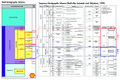
File:M115CH10FG04.jpg ...isher field. Also shown are the BP genetic sequences based on [[Kingfisher field|Partington et al. (1993)]]. From AAPG Memoir 115—Rift-Related Coarse-Grai(1,266 × 845 (845 KB)) - 18:43, 17 January 2019
File:M91Ch11FG69.JPG ...oil field. From Shepherd, M., 2009, Lithofacies maps, in M. Shepherd, Oil field production geology: AAPG Memoir 91, p. 93-98.(600 × 606 (106 KB)) - 15:42, 27 April 2015
File:M91FG190.JPG ...the AAPG. From Shepherd, M., 2009, Deltaic reservoirs, in M. Shepherd, Oil field production geology: AAPG Memoir 91, p. 279-288.(800 × 1,047 (162 KB)) - 18:05, 20 August 2015- #REDIRECT [[Sorrento field: water saturation]]46 bytes (5 words) - 16:17, 21 November 2014
- #REDIRECT [[Sorrento field: water saturation]]46 bytes (5 words) - 16:16, 21 November 2014
- #REDIRECT [[Magnetic field: local variations]]46 bytes (5 words) - 21:19, 14 May 2014
- #REDIRECT [[Sorrento field: water saturation]]46 bytes (5 words) - 16:15, 21 November 2014
- ...-field) measurement. The E-field is always measured perpendicular to the H-field data. ==The H-field==4 KB (519 words) - 19:57, 27 January 2022
File:Mth14ch04f02.jpg ...nd Conclusions of a Horizontal-drilling Program at South Pass 62 Salt-dome Field, by E. P. Mason, M. J. Bastian, R. Detomo, M. N. Hashem, and A. J. Hildebra(500 × 718 (88 KB)) - 16:08, 7 December 2015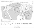
File:M91Ch11FG72.JPG ...= gamma-ray log. Shepherd, M., 2009, Lithofacies maps, in M. Shepherd, Oil field production geology: AAPG Memoir 91, p. 93-98.(800 × 658 (69 KB)) - 15:51, 27 April 2015- #REDIRECT [[Morrow lithofacies and pore types: Sorrento field]]63 bytes (8 words) - 12:35, 4 June 2014
File:Mth14ch07f01.jpg ...ique Horizontal-well Designs Boost Primary and EOR Production, Prudhoe Bay Field, Alaska , by R. S. Tye, B. A. Watson, P. L. McGuire, and M. M. Maguire, Pag(700 × 809 (135 KB)) - 17:34, 7 December 2015
File:M91FG184.JPG ...rom AAPG. From Shepherd, M., 2009, Deltaic reservoirs, in M. Shepherd, Oil field production geology: AAPG Memoir 91, p. 279-288.(800 × 1,134 (191 KB)) - 20:10, 12 August 2015- #REDIRECT [[Sediment thickness and field location maps: Gulf of Mexico example]]80 bytes (11 words) - 21:04, 19 December 2014
File:M91Ch13FG92.JPG .... From Shepherd, M., 2009, Structural geology: Faults, in M. Shepherd, Oil field production geology: AAPG Memoir 91, p. 107-122.(600 × 517 (60 KB)) - 21:40, 29 April 2015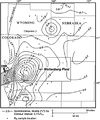
File:BasinCenteredGasFig14.jpg ...Sandstone in the Wattenburg field (modified from Higley et al., 1992). The field is nearly coincident with the 0.9% isoreflectance contour (Higley et al., 1(400 × 478 (53 KB)) - 16:30, 11 March 2015
File:M91Ch11FG71.JPG ...al., 2002). From Shepherd, M., 2009, Lithofacies maps, in M. Shepherd, Oil field production geology: AAPG Memoir 91, p. 93-98.(800 × 629 (79 KB)) - 15:48, 27 April 2015
File:Core-log-transformations-and-porosity-permeability-relationships fig5.png ...permeability (run under stress) versus helium porosity from McArthur River Field, Alaska.(912 × 1,127 (19 KB)) - 18:06, 14 January 2014
File:Mth14ch07f02.jpg ...ique Horizontal-well Designs Boost Primary and EOR Production, Prudhoe Bay Field, Alaska , by R. S. Tye, B. A. Watson, P. L. McGuire, and M. M. Maguire, Pag(500 × 923 (106 KB)) - 17:50, 7 December 2015
File:Mth14ch04f03.jpg ...nd Conclusions of a Horizontal-drilling Program at South Pass 62 Salt-dome Field, by E. P. Mason, M. J. Bastian, R. Detomo, M. N. Hashem, and A. J. Hildebra(500 × 495 (47 KB)) - 16:09, 7 December 2015
File:M91Ch13FG84.JPG .... From Shepherd, M., 2009, Structural geology: Faults, in M. Shepherd, Oil field production geology: AAPG Memoir 91, p. 107-122.(600 × 766 (134 KB)) - 21:34, 29 April 2015
File:Mth14ch02f03.jpg ...Turbidite Reservoir--The ARCO-DOE 91X-3 Horizontal Well Project, Yowlumne Field, San Joaquin Basin, California in AAPG Methods in Exploration No. 14: Horiz(700 × 529 (75 KB)) - 15:26, 4 December 2015
File:Mth14ch02f08.jpg ...Turbidite Reservoir--The ARCO-DOE 91X-3 Horizontal Well Project, Yowlumne Field, San Joaquin Basin, California in AAPG Methods in Exploration No. 14: Horiz(400 × 465 (28 KB)) - 20:19, 4 December 2015
File:Mth14ch04f06.jpg ...nd Conclusions of a Horizontal-drilling Program at South Pass 62 Salt-dome Field, by E. P. Mason, M. J. Bastian, R. Detomo, M. N. Hashem, and A. J. Hildebra(800 × 563 (141 KB)) - 16:55, 7 December 2015
File:Paleontology fig3.png Correlation of Rodessa Formation lithofacies at Running Duke Field, Houston County, Texas. Cores are indicated by solid vertical lines. (From(1,973 × 1,229 (190 KB)) - 17:38, 14 January 2014
File:Conducting-a-reservoir-simulation-study-an-overview fig3.png Model grid overlain on Khursaniyah field, Saudi Arabia. (From Boberg, 1974; Copyright © 1974 Society of Petroleum E(926 × 1,188 (30 KB)) - 18:46, 14 January 2014
File:Mth14ch04f05.jpg ...nd Conclusions of a Horizontal-drilling Program at South Pass 62 Salt-dome Field, by E. P. Mason, M. J. Bastian, R. Detomo, M. N. Hashem, and A. J. Hildebra(700 × 469 (63 KB)) - 16:53, 7 December 2015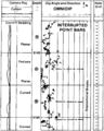
File:Dipmeters fig7.png Field example of a detailed dip computation through a sequence of interrupted mea(955 × 1,189 (73 KB)) - 01:19, 14 January 2014
File:PinedaleFieldLandRig.png Drilling rig in Pinedale field with the Wind River Mountains, Wyoming, USA in the background. Photo by Dou(600 × 400 (426 KB)) - 21:00, 14 March 2014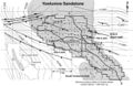
File:Mth14ch02f01.jpg ...Turbidite Reservoir--The ARCO-DOE 91X-3 Horizontal Well Project, Yowlumne Field, San Joaquin Basin, California in AAPG Methods in Exploration No. 14: Horiz(700 × 457 (103 KB)) - 23:18, 3 December 2015
File:Mth14ch04f01.jpg ...nd Conclusions of a Horizontal-drilling Program at South Pass 62 Salt-dome Field, by E. P. Mason, M. J. Bastian, R. Detomo, M. N. Hashem, and A. J. Hildebra(700 × 525 (111 KB)) - 16:00, 7 December 2015
File:Mthch02f02.jpg ...Turbidite Reservoir--The ARCO-DOE 91X-3 Horizontal Well Project, Yowlumne Field, San Joaquin Basin, California in AAPG Methods in Exploration No. 14: Horiz(300 × 453 (36 KB)) - 15:19, 4 December 2015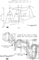
File:Subsurface-maps fig4.png (a) Cross section and (b) net pay Isopach map of the Strachan gas field, western Canada. Contour Interval is 100 ft. (From Hriskevich et al., 1980.(890 × 1,386 (78 KB)) - 20:42, 14 January 2014
File:M91Ch6FG40.JPG ...on display. From Shepherd, M., 2009, Sources of data, in M. Shepherd, Oil field production geology: AAPG Memoir 91, p. 49-63.(600 × 402 (45 KB)) - 16:55, 3 June 2015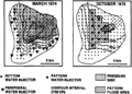
File:Subsurface-maps fig3.png Map of pressure response to pattern flood, Judy Creek field, western Canada, 1974 and 1975. Contour interval is 2750 kPa. (After Jardin(931 × 665 (79 KB)) - 20:42, 14 January 2014
File:Mth14ch07f03.jpg ...ique Horizontal-well Designs Boost Primary and EOR Production, Prudhoe Bay Field, Alaska , by R. S. Tye, B. A. Watson, P. L. McGuire, and M. M. Maguire, Pag(700 × 409 (77 KB)) - 17:55, 7 December 2015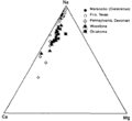
File:Oilfield-water-analysis fig1.png Triangular plot showing relative amounts of cations in typical oil field brines. Relative amount of sodium changes, but calcium is always about five(896 × 824 (10 KB)) - 17:24, 14 January 2014
File:Reef1.png ...modeling of Figure 7 and (B) seismic section of the structure at Appleton field (modified from Balch and Hart, 2000).(471 × 491 (248 KB)) - 16:08, 20 November 2014
File:M115CH11FG03.jpg Summary of the “Brae Play” ([[Thelma field|Fraser et al., 2003]]). From AAPG Memoir 115—Rift-Related Coarse-Grained(1,283 × 870 (408 KB)) - 15:13, 22 January 2019
File:M91FG175.JPG ...rom Shepherd, M., 2009, Meandering fluvial reservoirs, in M. Shepherd, Oil field production geology: AAPG Memoir 91, p. 261-272.(800 × 520 (107 KB)) - 19:54, 3 August 2015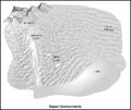
File:M91FG170.JPG ...ironments. From Shepherd, M., 2009, Eolian reservoirs, in M. Shepherd, Oil field production geology: AAPG Memoir 91, p. 255-259.(800 × 670 (90 KB)) - 17:03, 29 July 2015
File:M91FG171.JPG ...ents. From From Shepherd, M., 2009, Eolian reservoirs, in M. Shepherd, Oil field production geology: AAPG Memoir 91, p. 255-259.(800 × 734 (138 KB)) - 17:18, 29 July 2015
File:Subsurface-maps fig6.png ...maps for the B and C zones from the San Andres Formation reservoir, Jordan field, Ector and Crane Counties, Texas. Contours in PV fraction-feet. (After Majo(1,944 × 1,484 (237 KB)) - 20:42, 14 January 2014
File:M91FG176.JPG ...rom Shepherd, M., 2009, Meandering fluvial reservoirs, in M. Shepherd, Oil field production geology: AAPG Memoir 91, p. 261-272.(800 × 929 (161 KB)) - 20:28, 3 August 2015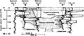
File:Evaluating-diagenetically-complex-reservoirs fig1.png Cross section in the Crane Field, Richland County, Montana, showing extreme irregularities in the developmen(952 × 409 (46 KB)) - 18:46, 14 January 2014
File:Subsurface-maps fig7.png ...r the A, B, C, and D zones from the San Andres Formation reservoir, Jordan field, Ector and Crane counties, Texas. Contours in MSTB/year/acre. (After Major(944 × 1,353 (62 KB)) - 20:42, 14 January 2014
File:M91Ch6FG48.JPG ...urther use). From Shepherd, M., 2009, Sources of data, in M. Shepherd, Oil field production geology: AAPG Memoir 91, p. 49-63.(600 × 428 (145 KB)) - 17:23, 3 June 2015
File:FG18CoreSt63Appendix3.JPG ...atomy of a giant carbonate reservoir: Fullerton Clear Fork (Lower Permian) field, Permian Basin, Texas: AAPG Studies in Geology 63.(600 × 890 (315 KB)) - 16:10, 29 June 2015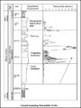
File:M91FG108.JPG ...barrier bar-shoreface interval of the Brent Group reservoir in the Thistle field, UK North Sea, shows an upward-increasing permeability profile. This patter(800 × 1,069 (99 KB)) - 21:26, 12 August 2015
File:M91Ch13FG87.JPG .... From Shepherd, M., 2009, Structural geology: Faults, in M. Shepherd, Oil field production geology: AAPG Memoir 91, p. 107-122.(600 × 396 (78 KB)) - 21:36, 29 April 2015
File:Geological-cross-sections fig1.png ...sections of the Ranger Formation in the Long Beach unit of the Wilmington field, California. Sections are projected onto a north-south plane. (From Slatt e(1,958 × 1,420 (129 KB)) - 15:32, 14 January 2014
File:M91Ch6FG45.JPG ...rvoir sweep. From Shepherd, M., 2009, Sources of data, in M. Shepherd, Oil field production geology: AAPG Memoir 91, p. 49-63.(800 × 838 (77 KB)) - 17:13, 3 June 2015
File:M91Ch13FG81.JPG .... From Shepherd, M., 2009, Structural geology: Faults, in M. Shepherd, Oil field production geology: AAPG Memoir 91, p. 107-122.(600 × 525 (31 KB)) - 21:15, 29 April 2015- ...ntral Utah [[Overthrust]] Belt in 2004, and subsequently Utah’s Providence Field. The fields comprise a 100-million-barrel province in an area the U.S. Geol ...entral Utah prospects drilled. After Wolverine’s discovery of the Covenant Field in Utah, Strickland founded Jayden Consulting LLC. Strickland died unexpect4 KB (525 words) - 19:41, 14 February 2017
File:M91Ch2FG6.JPG ...ing further. From Shepherd, M., 2009, Drilling a well, in M. Shepherd, Oil field production geology: AAPG Memoir 91, p. 7-12.(800 × 847 (167 KB)) - 17:01, 22 April 2015
File:M115CH11FG08.jpg ...es represent some of the various free water levels illustrated in [[Thelma field|Figure 9]]. From AAPG Memoir 115—Rift-Related Coarse-Grained Submarine Fa(743 × 1,103 (935 KB)) - 15:27, 22 January 2019
File:M91Ch13FG90.JPG .... From Shepherd, M., 2009, Structural geology: Faults, in M. Shepherd, Oil field production geology: AAPG Memoir 91, p. 107-122.(600 × 823 (51 KB)) - 21:39, 29 April 2015
File:M91FG187.JPG ...ers. From From Shepherd, M., 2009, Deltaic reservoirs, in M. Shepherd, Oil field production geology: AAPG Memoir 91, p. 279-288.(800 × 620 (61 KB)) - 20:04, 13 August 2015- ...Tectonic and sedimentation model for Morrow sandstone deposition, Sorrento field area, Denver basin, Colorado: The Mountain Geologist, October, p. 180-191.< ...-and-performance_fig9-85.png|Figure 1]] shows the location of the Sorrento field. Structure is contoured on the base of the Pennsylvanian.3 KB (429 words) - 14:19, 11 April 2022
File:MainPageFG18CoreSt63Appendix3.jpg ...atomy of a giant carbonate reservoir: Fullerton Clear Fork (Lower Permian) field, Permian Basin, Texas: AAPG Studies in Geology 63. Used on Core description(400 × 400 (104 KB)) - 16:14, 29 June 2015
File:M91Ch13FG91.JPG .... From Shepherd, M., 2009, Structural geology: Faults, in M. Shepherd, Oil field production geology: AAPG Memoir 91, p. 107-122.(600 × 736 (137 KB)) - 21:40, 29 April 2015
File:M91Ch13FG82.JPG .... From Shepherd, M., 2009, Structural geology: Faults, in M. Shepherd, Oil field production geology: AAPG Memoir 91, p. 107-122.(600 × 820 (92 KB)) - 21:16, 29 April 2015
File:M91Ch11FG70.JPG ...ett, 1996). From Shepherd, M., 2009, Lithofacies maps, in M. Shepherd, Oil field production geology: AAPG Memoir 91, p. 93-98.(600 × 353 (134 KB)) - 15:46, 27 April 2015
File:M91Ch13FG86.JPG .... From Shepherd, M., 2009, Structural geology: Faults, in M. Shepherd, Oil field production geology: AAPG Memoir 91, p. 107-122.(600 × 444 (30 KB)) - 21:35, 29 April 2015
File:CN24FG3.jpg Dark field transmission electron micrograph of a calcium dolomite (Ca1.12Mg0.88(CO2)x)(496 × 611 (128 KB)) - 20:47, 15 July 2015
File:M115CH02FG04.jpg West-east seismic section across the South Viking Graben, through Sycamore field. Location shown on [[South Viking Graben|Figures 1, 2, 3]]. Courtesy of PGS(700 × 662 (290 KB)) - 21:44, 10 January 2019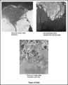
File:M91FG185.JPG ...ory.com). From Shepherd, M., 2009, Deltaic reservoirs, in M. Shepherd, Oil field production geology: AAPG Memoir 91, p. 279-288.(800 × 989 (133 KB)) - 18:40, 13 August 2015
File:Basic-seismic-processing fig1.png A single shot record as it is recorded in the field. The shot is at station 60. There were 120 geophones laid out in this “sp(1,946 × 2,027 (504 KB)) - 19:35, 14 January 2014
File:Subsurface-maps fig2.png ...re of the base of the Humber unconformity (top of the Brent Group), Dunlin field, U.K. Northern North Sea mapped with 1979 and 1989 vintage data. Contours a(936 × 1,378 (102 KB)) - 20:42, 14 January 2014
File:M91FG182.JPG .... From Shepherd, M., 2009, Braided fluvial reservoirs, in M. Shepherd, Oil field production geology: AAPG Memoir 91, p. 273-277.(800 × 1,040 (126 KB)) - 18:47, 12 August 2015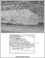
File:M91FG178.JPG ...rom Shepherd, M., 2009, Meandering fluvial reservoirs, in M. Shepherd, Oil field production geology: AAPG Memoir 91, p. 261-272.(800 × 1,042 (186 KB)) - 21:26, 3 August 2015- ...on for a field and looks for ways of getting more hydrocarbons out of that field. In a large company, this team will include some combination of the job tit ...s within a subsurface team.<ref name=Shepherd_2009>Shepherd, M., 2009, Oil Field Production Geology: [http://store.aapg.org/detail.aspx?id=788 AAPG Memoir 93 KB (424 words) - 14:54, 10 November 2014
- ...ortant step of any field project. Once this is done, the objectives of the field program fall into place. * [[Preparing to go to the field]]2 KB (354 words) - 22:07, 1 February 2022
File:M115CH10FG01.jpg Location map of the Kingfisher field in UKCS Blocks 16/8a and 16/8d showing the nearby producing Brae area field(1,279 × 723 (781 KB)) - 18:33, 17 January 2019- ...ts and not necessarily in response to structural [[dip]]. Gas in the Beryl field, for example, migrated downdip during production in response to changing pr ==Fault seal and field unitization==3 KB (479 words) - 15:21, 30 March 2022
File:M91FG112.JPG ...draulic units showing different pressures. This example is from the Magnus field in the UK North Sea (from Morris et al., 1999). Reprinted with permission f(800 × 856 (118 KB)) - 19:29, 18 August 2015
File:M115CH11FG04.jpg ...an additional trapping mechanism (line of section illustrated on [[Thelma field|Figure 2]]). From AAPG Memoir 115—Rift-Related Coarse-Grained Submarine F(1,277 × 860 (520 KB)) - 15:21, 22 January 2019- ...sification-of-exploration-traps_fig2-3.png|{{figure number|1}}Upper Valley field, Utah. Courtesy Rocky Mountain Association of Geologists. ...traps_fig2-4.png|{{figure number|2}}Formal classification for Upper Valley field.4 KB (538 words) - 18:47, 12 April 2022

File:M91FG180.JPG ...rom Shepherd, M., 2009, Meandering fluvial reservoirs, in M. Shepherd, Oil field production geology: AAPG Memoir 91, p. 261-272.(800 × 474 (56 KB)) - 15:53, 10 August 2015- ...Ogyopsis klotzi from the Mt. Stephen Trilobite Beds (Middle Cambrian) near Field, British Columbia, Canada.; Photograph taken by Mark A. Wilson (Department563 bytes (70 words) - 18:08, 2 February 2015
File:M91Ch13FG85.JPG .... From Shepherd, M., 2009, Structural geology: Faults, in M. Shepherd, Oil field production geology: AAPG Memoir 91, p. 107-122.(600 × 303 (34 KB)) - 21:34, 29 April 2015
File:Evaluating-structurally-complex-reservoirs fig3.png Cross section through an asymmetric ramp anticline, Whitney Canyon field, Wyoming, with SCAT and isogon data superimposed. Unconformities, axial pla(942 × 1,424 (112 KB)) - 18:47, 14 January 2014
File:M91Ch13FG94.JPG .... From Shepherd, M., 2009, Structural geology: Faults, in M. Shepherd, Oil field production geology: AAPG Memoir 91, p. 107-122.(800 × 345 (49 KB)) - 21:41, 29 April 2015
File:BasinCenteredGasFig3.jpg ...er basin, showing major structural elements and the locations of the Jonah field, the Belco 3-28 Merna and El Paso Natural Gas 1 Wagon Wheel wells, and cros(600 × 611 (63 KB)) - 22:19, 13 January 2015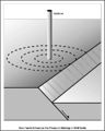
File:M91Ch13FG83.JPG .... From Shepherd, M., 2009, Structural geology: Faults, in M. Shepherd, Oil field production geology: AAPG Memoir 91, p. 107-122.(600 × 749 (49 KB)) - 21:16, 29 April 2015- ==Benton field== ...9–34 m (94–110 ft) of hydrocarbon. The actual column of hydrocarbon in the field in the Tar Springs Formation reservoir is [[length::29 m]] [[depth::(95 ft]4 KB (587 words) - 13:36, 1 April 2022
- ...1nov/1699/1699.htm Appleton field case study (eastern Gulf coastal plain): Field development model for Upper Jurassic microbial reef reservoirs associated w2 KB (298 words) - 21:30, 21 November 2014
File:M91Ch6FG46.JPG ...e water cut. From Shepherd, M., 2009, Sources of data, in M. Shepherd, Oil field production geology: AAPG Memoir 91, p. 49-63.(800 × 607 (60 KB)) - 17:17, 3 June 2015
File:M91FG172.JPG ....nasa.gov. From Shepherd, M., 2009, Eolian reservoirs, in M. Shepherd, Oil field production geology: AAPG Memoir 91, p. 255-259.(800 × 1,164 (226 KB)) - 19:51, 29 July 2015
File:M91FG181.JPG .... From Shepherd, M., 2009, Braided fluvial reservoirs, in M. Shepherd, Oil field production geology: AAPG Memoir 91, p. 273-277.(600 × 805 (104 KB)) - 21:18, 10 August 2015
File:M91Ch13FG89.JPG .... From Shepherd, M., 2009, Structural geology: Faults, in M. Shepherd, Oil field production geology: AAPG Memoir 91, p. 107-122.(600 × 632 (54 KB)) - 21:38, 29 April 2015
File:M91FG173.JPG ...rom Shepherd, M., 2009, Meandering fluvial reservoirs, in M. Shepherd, Oil field production geology: AAPG Memoir 91, p. 261-272.(800 × 878 (161 KB)) - 16:11, 31 July 2015- ...tural-gas wells or at small gas/oil separators in the field; also called [[field condensate]]) and consist primarily of [https://en.wikipedia.org/wiki/Penta ...l per mmcf. The ratio, of course, varies from petroleum field to petroleum field and from country to country, and the overall world average can only be calc4 KB (549 words) - 16:31, 25 June 2015
- ...ent uplift; WF = Waterpocket fold; A = Absaroka thrust fault. (c) Covenant field locality map of central Utah. From Parry, et. al<ref name=Parry />]] ...hitecture, petroleum systems, and geological implications for the Covenant field discovery, Sevier County, Utah]: AAPG Search and Discovery Article No. 11006 KB (897 words) - 19:39, 14 February 2017
File:M91Ch2.JPG ...production. From Shepherd, M., 2009, Drilling a well, in M. Shepherd, Oil field production geology: AAPG Memoir 91, p. 7-12.(800 × 831 (175 KB)) - 21:14, 22 April 2015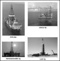
File:M91Ch2FG5.JPG ...ide.com.au). From Shepherd, M., 2009, Drilling a well, in M. Shepherd, Oil field production geology: AAPG Memoir 91, p. 7-12.(600 × 606 (66 KB)) - 16:49, 22 April 2015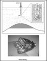
File:M91Ch2FG4.JPG ...the surface. From Shepherd, M., 2009, Drilling a well, in M. Shepherd, Oil field production geology: AAPG Memoir 91, p. 7-12.(800 × 1,046 (200 KB)) - 16:45, 22 April 2015- * Nondestructive; measures an existing field through a passive measurement ...ppm of the total field. Several corrections are made to remove the earth's field from the total measurement to image these anomalies. For petroleum explorat5 KB (720 words) - 17:59, 24 January 2022
- ==Example: Hudson field== ...een years after the initial well, the 210/24a-3 well discovered the Hudson field: a fault-dependent trap.5 KB (785 words) - 17:04, 29 March 2022
File:M91FG174.JPG ...rom Shepherd, M., 2009, Meandering fluvial reservoirs, in M. Shepherd, Oil field production geology: AAPG Memoir 91, p. 261-272.(800 × 639 (117 KB)) - 16:13, 31 July 2015- ...of faults controlling the distribution of hydrocarbons within a Gulf Coast field.]] ...tains 33 separate [[reservoir]] sands. At each mapped reservoir level, the field is divided into three major compartments (A, B, D) by faults. Compartment D4 KB (515 words) - 21:31, 29 March 2022
File:M91FG189.JPG ...the AAPG. From Shepherd, M., 2009, Deltaic reservoirs, in M. Shepherd, Oil field production geology: AAPG Memoir 91, p. 279-288.(800 × 544 (102 KB)) - 16:57, 20 August 2015
File:Flow-units-for-reservoir-characterization fig2.png ...b) flow unit subdivision of the Shannon Sandstone body in the Hartzog Draw field, Powder River basin, Wyoming. (Modified from Hearn et al., 1984.) (c) Litho(2,737 × 1,751 (237 KB)) - 23:14, 14 January 2014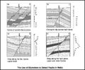
File:M91Ch13FG80.JPG .... From Shepherd, M., 2009, Structural geology: Faults, in M. Shepherd, Oil field production geology: AAPG Memoir 91, p. 107-122.(800 × 660 (102 KB)) - 21:14, 29 April 2015
File:M91FG123.png ...AAPG. From Shepherd, M., 2009, Geostatistical methods, in M. Shepherd, Oil field production geology: AAPG Memoir 91, p. 159–174.(2,064 × 2,095 (121 KB)) - 19:40, 13 August 2015
File:M115CH10FG05.jpg ...the Brae 2 and Brae 1 intervals, respectively. Modified from [[Kingfisher field|Turner and Connell (1991) and Spence and Kreutz (2003)]]. From AAPG Memoir(1,281 × 934 (1.29 MB)) - 18:44, 17 January 2019
File:M91FG186.JPG ...PG). From From Shepherd, M., 2009, Deltaic reservoirs, in M. Shepherd, Oil field production geology: AAPG Memoir 91, p. 279-288.(800 × 1,137 (157 KB)) - 19:22, 13 August 2015- ...seen in well logs or outcrops to [[Seismic data|seismic field data]]. The field data need to have been [[Seismic migration|migrated]], since only then does ...Phase (waves)|phase]], then manually aligning the simulated trace with the field trace(s) in the vicinity of the well. This is normally done over some limit3 KB (486 words) - 19:10, 27 January 2022
- ...f name=ch10r10>Buck, S., Robertson, G., 1996, Fault seal behavior at Beryl field, UK North Sea: observations from 20 years of production, drilling and injec ....datapages.com/data/bulletns/1992-93/data/pg/0077/0008/1350/1389.htm Akaso field, Nigeria: use of integrated 3-D seismic, fault-slicing, clay smearing and R4 KB (530 words) - 15:21, 30 March 2022
File:Evaluating-structurally-complex-reservoirs fig1.png ...the complex structure seen in the discovery well of the Rail Road Gap oil field, California. The five plot types are (from left to right) azimuth versus de(1,933 × 1,167 (174 KB)) - 18:47, 14 January 2014
File:M91Ch06FG44.JPG ...f depletion. From Shepherd, M., 2009, Sources of data, in M. Shepherd, Oil field production geology: AAPG Memoir 91, p. 49-63.(800 × 696 (58 KB)) - 17:11, 3 June 2015- Planning and logistics are key components for the success of any field party. An important pre-field step is to review previous work. This includes finding and evaluating previ5 KB (730 words) - 22:36, 1 February 2022
- ...for the Oil & Gas domain. Established & managed by highly experienced oil field engineers, our Products match the highest quality & reliability Standards s Our Team of Oil field Engineers and Highly Experienced Consultants are equipped with excellence o2 KB (263 words) - 03:59, 18 June 2019
- ...name=ch09r9>Chetin, A. K., and W. W. Fitkin, 1959, Geology of the Weyburn field, Saskatchewan: Canadian Mining and Metallurgical Bulletin, December, p. 751 ...erformance_fig9-96.png|Figure 1]] is a map showing the location of Weyburn field.6 KB (848 words) - 17:34, 3 January 2024
File:Mth14ch04f04.jpg ...nd Conclusions of a Horizontal-drilling Program at South Pass 62 Salt-dome Field, by E. P. Mason, M. J. Bastian, R. Detomo, M. N. Hashem, and A. J. Hildebra(400 × 202 (17 KB)) - 16:51, 7 December 2015- ...rned with the correct succession of rock formations and it still remains a field of primary concern to all geologists. ...sedimentology] is rapidly becoming an invaluable aid in stratigraphy. This field has for its study the processes and agencies through which layers of sedime4 KB (561 words) - 21:20, 1 February 2023
File:M106Ch12Table4c.jpg ..., argillaceous limestone (arg limestone), shale, marl, and evaporite-marl. Field number refers to locations shown in Figure 3 of [[Iraq petroleum geology]].(700 × 906 (160 KB)) - 15:42, 12 May 2016
File:M106Ch12Table4d.jpg ..., argillaceous limestone (arg limestone), shale, marl, and evaporite-marl. Field number refers to locations shown in Figure 3 of [[Iraq petroleum geology]].(700 × 423 (78 KB)) - 15:42, 12 May 2016
File:M106Ch12Table4.jpg ..., argillaceous limestone (arg limestone), shale, marl, and evaporite-marl. Field number refers to locations shown in Figure 3 of [[Iraq petroleum geology]].(700 × 438 (80 KB)) - 15:41, 12 May 2016
File:M106Ch12Table4a.jpg ..., argillaceous limestone (arg limestone), shale, marl, and evaporite-marl. Field number refers to locations shown in Figure 3 of [[Iraq petroleum geology]].(700 × 891 (157 KB)) - 15:41, 12 May 2016
File:M106Ch12Table4b.jpg ..., argillaceous limestone (arg limestone), shale, marl, and evaporite-marl. Field number refers to locations shown in Figure 3 of [[Iraq petroleum geology]].(700 × 888 (149 KB)) - 15:41, 12 May 2016- [[File:BarnettShalePlayFig1.png|thumb|300px|{{figure number|1}}Barnett Shale Field.<ref>[http://www.tceq.state.tx.us/assets/public/implementation/barnett_shal ...ales of the Mississippian aged Barnett shale. The Newark East field is the field designation established by the Texas Railroad Commission for productive por6 KB (909 words) - 19:24, 14 March 2019
- ...techniques available, improves success ratios and reduces costly errors in field development. * Distribution and movement of hydrocarbons during field development4 KB (528 words) - 17:48, 24 March 2022
File:M91Ch13FG93.JPG ...ology. Shepherd, M., 2009, Structural geology: Faults, in M. Shepherd, Oil field production geology: AAPG Memoir 91, p. 107-122.(600 × 704 (72 KB)) - 21:40, 29 April 2015
File:Mth14ch07f04.jpg ...ique Horizontal-well Designs Boost Primary and EOR Production, Prudhoe Bay Field, Alaska , by R. S. Tye, B. A. Watson, P. L. McGuire, and M. M. Maguire, Pag(500 × 258 (39 KB)) - 17:58, 7 December 2015
File:M91Ch13FG88.JPG .... From Shepherd, M., 2009, Structural geology: Faults, in M. Shepherd, Oil field production geology: AAPG Memoir 91, p. 107-122.(600 × 585 (272 KB)) - 21:36, 29 April 2015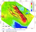
File:M115CH10FG02.jpg ...are in 100 ft (30 m) TVD increments. Area of map is shown in [[Kingfisher field|Figure 1]]. From AAPG Memoir 115—Rift-Related Coarse-Grained Submarine Fa(1,283 × 1,132 (1.55 MB)) - 18:38, 17 January 2019
File:Mth14ch02f06.jpg ...Turbidite Reservoir--The ARCO-DOE 91X-3 Horizontal Well Project, Yowlumne Field, San Joaquin Basin, California in AAPG Methods in Exploration No. 14: Horiz(700 × 481 (51 KB)) - 17:48, 4 December 2015
File:Evaluating-structurally-complex-reservoirs fig7.png Fault plane section and structure map of a model field to show the effects of synclinal and cross fault spilling. (a) Simple antic(861 × 1,502 (31 KB)) - 18:47, 14 January 2014
File:M106Ch12Fig02.jpg Bouguer gravity (right) and total magnetic field (left) maps of Iraq, from Jassim and Goff (2006), compiled by GEOSURV. The(700 × 373 (52 KB)) - 20:26, 11 May 2016- ....png|300px|thumb|{{figure number|1}}Cross section, map, and summary of the field. From Dale Winland, unpublished data.]] The following indicate from field production the presence of diagenetic traps.5 KB (611 words) - 21:06, 4 February 2022
- ==Example: Ekofisk field== ...-83/data/pg/0067/0002/0200/0201.htm Microfractures in chalks of Albuskjell field, Norwegian sector, North Sea: possible origin and distribution]: AAPG Bulle5 KB (742 words) - 17:11, 1 February 2022
File:Mth14ch02f04.jpg ...Turbidite Reservoir--The ARCO-DOE 91X-3 Horizontal Well Project, Yowlumne Field, San Joaquin Basin, California in AAPG Methods in Exploration No. 14: Horiz(500 × 605 (114 KB)) - 15:58, 4 December 2015- ...]]. Compared with more sophisticated exploration techniques, the cost of a field program is a bargain. Acquiring, processing, and interpreting [[seismic dat ...r proprietary nature. Similarly, in the literature, results of exploration field efforts are not specifically stated as such but tend to be buried in the br5 KB (771 words) - 21:12, 1 February 2022
File:Mth14ch02f07.jpg ...Turbidite Reservoir--The ARCO-DOE 91X-3 Horizontal Well Project, Yowlumne Field, San Joaquin Basin, California in AAPG Methods in Exploration No. 14: Horiz(700 × 449 (53 KB)) - 19:56, 4 December 2015- ...er|2}}Petrophysical characteristics of the main nonreservoir facies in the field: lime and dolomite mudstones to wackestones. ]] ...s the petrophysical characteristics of the main nonreservoir facies in the field: lime and dolomite mudstones to wackestones. The sample pore system consist6 KB (842 words) - 18:50, 4 December 2023
File:Mth14ch02f05.jpg ...Turbidite Reservoir--The ARCO-DOE 91X-3 Horizontal Well Project, Yowlumne Field, San Joaquin Basin, California in AAPG Methods in Exploration No. 14: Horiz(500 × 682 (64 KB)) - 17:07, 4 December 2015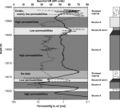
File:Mth14ch02f09.jpg ...Turbidite Reservoir--The ARCO-DOE 91X-3 Horizontal Well Project, Yowlumne Field, San Joaquin Basin, California in AAPG Methods in Exploration No. 14: Horiz(600 × 541 (60 KB)) - 20:21, 4 December 2015
File:M106Ch12Table3.jpg ...rite-marl. Alternative or old reservoir names provided in comments column. Field number refers to locations shown in Figure 3 of [[Iraq petroleum geology]].(700 × 823 (153 KB)) - 15:35, 12 May 2016
File:M106Ch12Table3a.jpg ...rite-marl. Alternative or old reservoir names provided in comments column. Field number refers to locations shown in Figure 3 of [[Iraq petroleum geology]].(700 × 896 (147 KB)) - 15:36, 12 May 2016
File:M106Ch12Table3b.jpg ...rite-marl. Alternative or old reservoir names provided in comments column. Field number refers to locations shown in Figure 3 of [[Iraq petroleum geology]].(700 × 336 (63 KB)) - 15:36, 12 May 2016- ...n|Pickett plot]] for the Midale vuggy beds from an example well in Weyburn field. Data points cluster around higher [[Basic_open_hole_tools#Resistivity|resi ...|1}}Pickett plot for the Midale vuggy beds from an example well in Weyburn field. Copyright: Coalson et al.;<ref name=Coalson1994>Coalson, E. B., S. M. Gool4 KB (588 words) - 17:01, 12 April 2022
- ==Field measurements== .../ref> Field instuments are capable of detecting differences in the earth's field between 0.000001 and 0.0001 Gal (or between 1 μGal and 0.1 mGal), dependin6 KB (854 words) - 16:19, 20 January 2022
- ...Tectonic and sedimentation model for Morrow sandstone deposition, Sorrento field area, Denver basin, Colorado: The Mountain Geologist, October, p. 180-191.< Morrow sandstones in the Sorrento field are slightly shaly, range in [[grain size]] from very coarse to fine, and a6 KB (769 words) - 17:23, 11 April 2022
- ...ter contacts and apparent anomalies in saturation profiles in the Sorrento field are due to multiple flow units from two separate reservoirs. This example u ...as Fields, p. 305–328.</ref> Reliably recognizing separate reservoirs in a field requires considering [[capillary pressure]]s, [[Free water level|heights ab7 KB (1,044 words) - 16:57, 13 April 2022
- ...by far the most important contributors to local variations in the magnetic field. ...ite content of sedimentary rocks. Consequently, variations in the magnetic field result mainly from basement rocks underlying the sedimentary section.10 KB (1,481 words) - 15:39, 24 January 2022
- ...perpendicular to the E<sub>y</sub> component. This is also true for the H-field components. ...y H<sub>x</sub> and H<sub>y</sub> components are measured), the vertical H-field component—if measured—provides information on the surface geology.5 KB (706 words) - 15:11, 31 January 2022
- Field development, including [[step-out]] drilling, and exploration are enhanced Reservoired oils in the East Breaks 160-161 field are more thermally [[Maturation|mature]] than the surrounding sediments, de4 KB (494 words) - 13:44, 5 December 2023
- ...ncountered virgin pressures in contrast to the lower pressures in the main field. ...ncountered virgin pressures in contrast to the lower pressures in the main field.3 KB (399 words) - 21:31, 24 March 2022
- ...antitative fault seal analysis. This discussion contains an example from a field in the Gulf Coast and demonstrates the application of routine fault seal an ...300px|thumb|{{figure number|1}}FPP of a portion of a fault in a Gulf Coast field.]]5 KB (769 words) - 18:12, 29 March 2022
- ...re porosity and permeability from the Midale in an example well at Weyburn field. Copyright: Coalson et al.;<ref name=Coalson1994>Coalson, E. B., S. M. Gool ...osity]] and [[permeability]] from the Midale in an example well at Weyburn field. The diagonal lines are contours of equal [[Characterizing_rock_quality#Wha5 KB (659 words) - 16:54, 12 April 2022
- ...nd conclusions of a horizontal-drilling program at South Pass 62 salt-dome field Prudhoe Bay field lies on the Alaska coastal plain between Naval Petroleum Reserve No. 4 (NPR11 KB (1,634 words) - 16:34, 26 April 2016
- ...]] of most hydrocarbons in a [[petroleum system]]. The East Breaks 160-161 field began to accumulate no earlier than 1.2 Ma when the trap began forming, and ...1, Seismic facies of slope basin turbidite reservoirs, East Breaks 160-161 field: Pliocene–Pleistocene, northwest- ern Gulf of Mexico, in P. Weimer and M.5 KB (715 words) - 17:07, 23 March 2022
- The action of developing adjustments in the well profile by using field observations to place the wellbore in the designated target is called Geost1 KB (185 words) - 19:43, 3 March 2016
- A [[migration]] pathway map is a fundamental tool for prospect assessment and field development. In simple [[migration pathway]] maps, arrows are drawn perpend ...across a fault. In this fault plane profile of a fault in a [[Gulf Coast]] field, the [[shale gouge ratio (SGR)]] was calculated and contoured only on areas3 KB (405 words) - 18:19, 29 March 2022
- ...'Hyal B ='' HB-2) from two different reservoirs in the East Breaks 160-161 field provide data for [[modeling]] the history of hydrocarbon generation and [[m ...chromatograms of crude oils from two reservoirs in the East Breaks 160-161 field. Copyright: Dow et al.<ref name=ch04r29 /> Courtesy Gulf Coast SEPM.5 KB (648 words) - 15:33, 23 March 2022
- ...n oil originated from a specific source. Oils from the East Breaks 160-161 field have been analyzed by Dow et al.<ref name=ch04r29>Dow, W. G., M. A. Yukler, ...eogene turbidite facies are unlikely to be the source of oils in the A-537 field and further speculate that deeper [[source rocks]] with a strong marine alg7 KB (1,080 words) - 17:44, 23 March 2022
- ...1, Seismic facies of slope basin turbidite reservoirs, East Breaks 160-161 field: Pliocene-Pleistocene, northwestern Gulf of Mexico ''in'' P. Weimer and M. ...seismic reflection profile along the west side of the East Breaks 160-161 field. From Armentrout and Clement.<ref name=Armentroutandclement_1990>Armentrout6 KB (850 words) - 15:33, 23 March 2022
- ...nd conclusions of a horizontal-drilling program at South Pass 62 salt-dome field ....jpg|Figure 2]], [[:file:Mth14ch04f03.jpg|Figure 3]]). A 3-D seismic-based field study completed in 1994 identified reservoir targets for the horizontal-dri9 KB (1,290 words) - 21:18, 19 October 2016
- ...e bodies with [[magnetics]] because of the inherent ambiguity of potential field methods in determining Z.<ref name=ch14r8>Skeels, D. C., 1947, Ambiguity in ==Oil field example==8 KB (1,109 words) - 17:41, 24 January 2022
- ...cal petroleum degradation within the Brent Group reservoir in the Gullfaks field, Norwegian North Sea: Organic Geochemistry, vol. 19, nos. 1–3, p. 107–1 ...cholson, G., 1980, Geology of the Kern River field, in Kern River Oilfield Field Trip: AAPG Pacific Section Guidebook, p. 7–17.</ref> Oil source is the sa8 KB (1,193 words) - 18:51, 1 February 2022
- ...turbidite reservoir: The ARCO-DOE 91X-3 horizontal well project, Yowlumne field, San Juaquin Basin, California Yowlumne is a giant oil field in the San Joaquin Basin, California ([[:file:Mth14ch02f01.jpg|Figure 1]]),13 KB (1,896 words) - 19:02, 11 March 2019
- ...then the capillary properties of the Midale marly beds could seal Weyburn field without hydronamics. As often happens in oil-field studies, this one did not yield a unique solution. This analysis is not suf5 KB (723 words) - 17:02, 12 April 2022
- ...-3.png|300px|thumb|{{figure number|3}}Map and cross section of Raven Creek field.]] Raven Creek field (with 40 million BOE) illustrates the importance of a bottom seal. It is a5 KB (632 words) - 20:26, 3 February 2022
- ...r86>Schanck, J. W., C. C. Cobb, and M. L. Ivey, Jr., 1988, East Breaks 160 field on the offshore Texas shelf edge: a model for deepwater exploration and dev ...1, Seismic facies of slope basin turbidite reservoirs, East Breaks 160-161 field: Pliocene–Pleistocene, northwestern Gulf of Mexico, in P. Weimer and M. J7 KB (952 words) - 18:44, 21 March 2022
- | title = Pinedale Field: Case Study of a Giant Tight Gas Sandstone Reservoir | chapter = The Significance of the Pinedale Field16 KB (2,521 words) - 17:13, 29 January 2016

File:M106Ch12Table2b.jpg List of oil and gas fields and wells with oil and/or gas shows. Field number refers to locations shown in Figure 3 of Iraq petroleum geology. Hyd(700 × 474 (70 KB)) - 15:30, 12 May 2016
File:M106Ch12Table2.jpg List of oil and gas fields and wells with oil and/or gas shows. Field number refers to locations shown in Figure 3 of [[Iraq petroleum geology]].(700 × 442 (69 KB)) - 15:28, 12 May 2016
File:M106Ch12Table2a.jpg List of oil and gas fields and wells with oil and/or gas shows. Field number refers to locations shown in Figure 3 of [[Iraq petroleum geology]].(700 × 515 (83 KB)) - 15:29, 12 May 2016- ...file:M106Ch06Fig02.jpg|Figure 1]]), began production in 2004 and the Tamar field in 2013. ...the Israeli economic water. The production and resource data of the Helez field (5) includes the combined amount in all three reservoir levels. The amount10 KB (1,276 words) - 21:00, 19 July 2016

File:M106Ch12Table2c.jpg List of oil and gas fields and wells with oil and/or gas shows. Field number refers to locations shown in Figure 3 of Iraq petroleum geology. Hyd(700 × 489 (73 KB)) - 15:30, 12 May 2016- ...tacked sandstones of the ''Glob alt'' reservoir at the East Breaks 160-161 field clearly demonstrates the need to carefully map the internal seismic facies ...''Trim A'' (A) and ''Glob alt'' (B) sandstones of the East Breaks 160-161 field. After Armentrout et al.<ref name=ch04r7>Armentrout, J. M., 1991, Paleontol6 KB (902 words) - 16:00, 24 March 2022
- ...al Williston Basin (North Dakota) and eastward into the region of Parshall Field. More than 5,000 Three Forks wells had been drilled by the end of 2020. Alt ...rg, S.A. and A. Pramudito, 2009, Petroleum geology of the giant Elm Coulee field, Williston Basin: AAPG Bulletin, v. 93, no. 9, pp. 1127-1153.7 KB (1,004 words) - 22:08, 4 March 2022
- It is important to identify stratigraphic complexities early in field development so that (1) operations can be tailored to optimize recovery and Problems associated with a stratigraphically complex field include difficulties in (1) drilling and completion and (2) reservoir chara8 KB (983 words) - 20:49, 19 January 2022
- ...the capture of details in sedimentary features for analysis away from the field, or for use in teaching.2 KB (239 words) - 19:40, 9 September 2014
- ...92, How 3D seismic-CAEX combination affected development of N. Frisco City field in Alabama: Oil & Gas Journal, vol. 90, no. 43, p. 127–130.</ref> Where t4 KB (556 words) - 20:56, 31 March 2022
- ...Reservoir Geology of the Upper Jurassic Brae Sandstone Member, Kingfisher Field, South Viking Graben, U.K. North Sea ...55–62.</ref><ref name=Fletcher2003b>Fletcher, K. J., 2003b, The South Brae Field, Blocks 16/07a, 16/07b, UK North Sea, in J. G. Gluyas and H. M. Hichens, ed16 KB (2,358 words) - 16:28, 11 January 2024
- ** Primary work location: office, field (stationary or mobile)1 KB (225 words) - 13:31, 6 August 2013
- ...x nature of the source field geometry (the geometry of the electromagnetic field or currents induced with the earth by the transmitter) may present quantita ...chniques are special cases of the DC method in which the induced potential field is measured and interpreted in terms of [[mineralogy]] and/or soil characte15 KB (2,130 words) - 21:19, 19 January 2022
- ...urement from the magnetometer after a model of the earth's normal magnetic field is removed. It is generally a reflection of the average magnetic susceptibi * [[Magnetic field: local variations]]4 KB (618 words) - 19:55, 27 January 2022
- ...ovement between [[Source rock|source]] and trap within a complexly faulted field and between fields. Migration maps that consist solely of [[dip]] arrows dr2 KB (261 words) - 18:12, 29 March 2022
- In the geological field, maps generated from data researchers had collected which then would be por ...gical map: Result of aerial photographs adapted to the actual condition on field.10 KB (1,547 words) - 14:07, 19 March 2019
- # Plot paleogeography, reservoir thickness, and field location on the same map. ...of canyons, shelf/slope break, shorelines, etc.), reservoir thickness, and field locations to trap development.11 KB (1,482 words) - 15:47, 21 March 2022
- ...rn Houston Metropolitan Area, Texas]: U.S. Geological Survey Miscellaneous Field Studies Map 1136</ref> ...n a larger scale. Where hanging wall intensively moves down moves down the field movement. Wedge shape set of fault blocks could develop the above faults de4 KB (630 words) - 18:28, 2 April 2019
- ...edge is always flat against the plane (Sometimes it is easier to put your field book against the outcrop and then the compass against the book to get a smo On June 16, 2015 Geophysics of University of Indonesia held Field Trip to Karangsambung, and observed strike of claystone at Kalimandala Kara5 KB (747 words) - 18:47, 26 March 2019
- ...dic movement of the north-bounding growth fault of the East Breaks 160-161 field ([[:File:Sedimentary-basin-analysis fig4-31.png|Figure 1]], nine cycles bet ...1, Seismic facies of slope basin turbidite reservoirs, East Breaks 160-161 field: Pliocene–Pleistocene, northwestern Gulf of Mexico, in P. Weimer and M. J8 KB (1,015 words) - 16:59, 23 March 2022
- ...et of known or predicted economic conditions. It is of importance from the field discovery, through initial appraisal and development phases, to final aband ...echniques], in J. A. Masters, ed., Elmworth—Case Study of a Deep Basin Gas Field: [http://store.aapg.org/detail.aspx?id=67 AAPG Memoir 38], p. 215–242.</r13 KB (1,799 words) - 19:01, 20 January 2022
- ...seismic reflection profile along the west side of the East Breaks 160-161 field. From Armentrout and Clement;<ref name=ch04r10 /> courtesy Gulf Coast SEPM. ...-161 intraslope minibasin, showing the location of the East Breaks 160-161 field.]]7 KB (1,022 words) - 21:54, 22 March 2022
- In geological field, maps which were generated from data whom researchers had collected which t ...n the result of aerial photographs that adapted to the actual condition on field.10 KB (1,654 words) - 06:11, 30 June 2015
- In geological field, maps which were generated from data whom researchers had collected which t ...n the result of aerial photographs that adapted to the actual condition on field.10 KB (1,633 words) - 05:38, 30 June 2015
- Because the depth to the probable [[source rocks]] of the East Breaks 160-161 field hydrocarbons is unknown, multiple working hypotheses must be considered. Fo ...intraslope [[minibasin]], showing the location of the East Breaks 160-161 field.]]6 KB (929 words) - 19:41, 22 March 2022
- ...–200,000 years in duration) to be the building blocks of most reservoir or field studies. ...eation of the middle Pennsylvanian (Desmoinesian), Paradox basin and Aneth field, southwestern USA, in J. F. Read, L. J. Weber, J. F. Sarg, and F. M. Wright5 KB (619 words) - 22:26, 3 February 2022
- ...ational or international meetings, symposia, workshops, short courses, and field trips, and by publishing in the AAPG Bulletin, the AAPG EXPLORER, in EMD me2 KB (294 words) - 23:39, 19 January 2021
- ...flow in a faulted reservoir system: fault trap analysis for the Block 330 field in Eugene Island, South Addition, offshore Louisiana]: AAPG Bulletin, vol. ....datapages.com/data/bulletns/1992-93/data/pg/0077/0008/1350/1389.htm Akaso field, Nigeria: use of integrated 3-D seismic, fault slicing, clay smearing and R5 KB (638 words) - 14:17, 2 February 2022
- | image = Oil-field-production-geology.png | title = Oil Field Production Geology8 KB (1,182 words) - 20:27, 3 March 2016
- ...hoe%20Bay%20-%20Oil/Prudhoe%20Bay,%20Prudhoe%20Bay/1_Oil_1.htm Prudhoe Bay field] in the [http://ngm.nationalgeographic.com/ngm/0605/feature1/ North Slope] * [[Prudhoe Bay field]]5 KB (778 words) - 21:14, 12 March 2019
- ...r86>Schanck, J. W., C. C. Cobb, and M. L. Ivey, Jr., 1988, East Breaks 160 field on the offshore Texas shelf edge: a model for deepwater exploration and dev ...[Hydrocarbon migration|migration]] pathways within the East Breaks 160-161 field. Based on data from Lovely and Ruggiero.<ref>Lovely and Ruggiero, 1995, per10 KB (1,376 words) - 16:00, 23 March 2022
- Once the critical factors from the analog field(s) are fully understood, we can devise the best exploration methods to deli ...ology]], and good old-fashioned [[The seven critical elements of fieldwork|field work]]. Cross-linears may be mapped from photogeology and [[Remote sensing|7 KB (962 words) - 16:03, 18 February 2022
- ...eservoir pressure. [[Artificial lift]] may not be required as early in the field's life since wells tend to have longer flowing lives. As in a solution gas ...initial gas cap, the structural geometry of the reservoir, and the way the field is managed.16 KB (2,374 words) - 20:46, 19 January 2022
- ...., and E. B. Coalson, 1990, Evaluation of the Morrow sandstone in Sorrento field, Cheyenne County, Colorado, ''in'' S. A. Sonnenberg, L. T. Shannon, K. Rade * [[Setting and structure of the Sorrento field]]7 KB (956 words) - 17:24, 11 April 2022
- | image = Oil-field-production-geology.png | title = Oil Field Production Geology13 KB (1,859 words) - 21:29, 12 March 2019
- ..., Geological factors influencing reservoir performance of the Hartzog Draw field: Journal of Petroleum Technology, v. 36, Aug., p. 1335–1344, DOI: [https: ...s in production mechanism (such as initiation of [[waterflooding]]) during field life.16 KB (2,282 words) - 20:46, 19 January 2022
- ...he register of the magnetic fields of the rocks, having the Earth magnetic field as reference. These fields are registered by a magnetometer installed in a ...the variation of rock density, taking as reference the Earth gravitational field ([[:File:Figura 1.jpeg|Figure 1]).5 KB (708 words) - 22:00, 10 April 2019
- * Few empirical field studies compare the predicted and observed [[hydrocarbon column]] heights.2 KB (325 words) - 20:57, 31 March 2022
- | image = Oil-field-production-geology.png | title = Oil Field Production Geology18 KB (2,607 words) - 15:33, 15 January 2024
- ...cross-leaking fault. The initial pressures of both wells lie on a common, field-wide pressure depletion curve. ...in a separate fault compartment encounters pressures equal to the current field depleted pressures, the fault is cross leaking.8 KB (1,155 words) - 21:31, 24 March 2022
- ...0-26.png|{{figure number|3}}Fault plane profile of a fault in a Gulf Coast field. ...gure 3]] is an example of a fault plane profile of a fault in a Gulf Coast field.6 KB (834 words) - 14:51, 29 March 2022
- ...cuna 3-D seismic survey ([[:File:Methods14ch08f01.jpg|Figure 1]]), Arecuna field contains an estimated 2.8 billion barrels of original oil in place, but to ==Geologic architecture of the Arecuna field==16 KB (2,381 words) - 19:03, 11 March 2019
- ...ta/specpubs/fieldst3/data/a017/a017/0001/0000/0031.htm Anschutz Ranch East Field], in E. A. Beaumont and N. H. Foster, eds., Structural Traps III, Atlas of ...general or specific impression of a trap. For example, East Anschutz Ranch field, shown in the map and [[cross section]] in [[:file:classification-of-explor8 KB (1,207 words) - 16:33, 13 April 2022
- ....datapages.com/data/bulletns/1992-93/data/pg/0077/0008/1350/1389.htm Akaso field, Nigeria: use of integrated 3-D seismic, fault-slicing, clay smearing and R ...C., H., Peters, M., P., A., M., Watts, N., W., Wilkie, J., T., 1993, Akaso field, Nigeria: use of integrated 3-D seismic, fault-slicing, clay smearing and R9 KB (1,327 words) - 16:32, 29 March 2022
- ...ing, appraisal, development and production are steps to assess a designate field for oil or gas prone. ...dure of all types of seismic survey is quite the same, when source used in field acquisition is geophone and marine is hydrophone.15 KB (2,331 words) - 19:12, 17 April 2019
- ...ds. This wide range extends from a decidedly marginally mature oil (in Hod field) to oils in which this parameter has reached equilibrium. ...oils from these eight fields but is reasonably constant within any single field. This finding is geologically significant since oil maturity increases from8 KB (1,116 words) - 22:16, 15 February 2022
- ...//en.wikipedia.org/wiki/Siberia Siberia], since its discovery in 1968. The field produces from both hydrates and free-gas reservoirs.7 KB (1,050 words) - 20:53, 6 January 2015
- ...., and E. B. Coalson, 1990, Evaluation of the Morrow sandstone in Sorrento field, Cheyenne County, Colorado, ''in'' S. A. Sonnenberg, L. T. Shannon, K. Rade ...ross section showing the facies and flow units present in the Hartzog Draw field of Wyoming. From Ebanks et al.;<ref name=Ebanks1993>Ebanks, J., N. H. Schei9 KB (1,231 words) - 18:42, 1 April 2022
- ! Field Name || Discovery Date || Reservoir Rock || [[API gravity|API Gravity]] (°2 KB (317 words) - 19:15, 25 January 2022
- ...in depth. Because seismic tomography measures the two-dimensional velocity field between the wellbores, it is usually represented by a color-coded map in wh ...ure 2]]. These traveltime data are then used to infer the seismic velocity field between the wellbores. If attenuation measurements can be made on the data,14 KB (2,060 words) - 20:51, 19 January 2022
- ...because one must learn to observe and record information accurately in the field, thinking in the third and fourth dimensions and developing a sense of the6 KB (826 words) - 14:29, 18 February 2022
- ...ell, L., Trumbly, P., 1990, Braidplain and deltaic reservoirs, Prudhoe Bay field, Alaska, in Barwis, J., McPherson, J., Studlick, J., eds., Sandstone Petrol6 KB (845 words) - 15:29, 1 February 2022
- A working trap model for Weyburn field is that of a macroporous vuggy packstone reservoir lying downdip from a mic ...Weyburn field oil densities grade from 35°API in the updip portion of the field to 27°API near the base. A representative [[gravity]] of 30°API is used f10 KB (1,484 words) - 20:55, 4 December 2023
- ...hut-in wells show pressure buildup, indicating transfer of fluids into the field at relatively rapid rates. It is, however, uncertain what portion of the re6 KB (877 words) - 19:33, 14 February 2022
- Variations in the local magnetic field are due mainly to the following: ...urves above the cross section are the magnetic profiles where the magnetic field is vertical for ''k''<sub>1</sub> > ''k''<sub>2</sub> and ''k''<sub>1</sub>6 KB (946 words) - 19:56, 27 January 2022
- ...pend on the its scale, and the density and accuracy of observations in the field. The final result from all [[geological methods]] is a geological map. ...steps of geological mapping consist of observation and measurement in the field, taking samples, and analyzing samples in a laboratory. Geological mapping29 KB (4,733 words) - 15:34, 15 January 2024
- ...From the result above, there is the same result beetwen sysntesis core and field core that give the image about the same changing pattern in rock pysical pr ...ty to increase the production rate. But, the rate of success aplication in field cannot give the justification of description about mechanism yet (Ariadi et11 KB (1,551 words) - 16:49, 11 January 2016
- ...in Well Wadi Sirhan-4 (WS-4). The second field in Jordan is the Hamzeh oil field in central North Jordan. However, with only modest original, recoverable re ....jpg|Figure 2]]) and the mid-Cretaceous sourced and reservoired Hamzeh oil field in central northern Jordan.16 KB (2,310 words) - 15:13, 19 January 2017
- * [[Example: mapping sediment thickness and field location]]3 KB (370 words) - 17:53, 18 February 2022
- ...he south and west sides of the San Juan basin, New Mexico and Arizona, 2nd Field Conference: New Mexico Geological Society, p. 124-131.</ref><ref name=Thade3 KB (411 words) - 15:01, 11 January 2016
- ...<ref name=Bishop_1982>Bishop, R. A., 1982, Whitney Canyon-Carter Creek gas field, SW Wyoming, ''in'' R. B. Powers, ed., Geological studies of the Cordillera ...ubs/fieldst3/data/a017/a017/0001/0000/0001.htm Whitney Canyon-Carter Creek Field-USA], ''in'' E. A. Beaumont and N. H. Foster, eds., Treatise of Petroleum G14 KB (1,897 words) - 20:01, 3 February 2022
- ...g, S. A. and A. Pramudito, 2009, Petroleum geology of the giant Elm Coulee field, Williston Basin: AAPG Bulletin, v. 93, no. 9, p. 1127–1153.</ref>; <ref11 KB (1,595 words) - 20:20, 2 June 2021
- | image = Oil-field-production-geology.png | title = Oil Field Production Geology24 KB (3,753 words) - 19:33, 3 March 2016
- | Volumetric || OOIP, OGIP, recoverable reserves. Use early in life of field. || Dependent on quality of reservoir description. Reserves estimates often ...able), recoverable reserves (assumes OOIP and OGIP known). Use in a mature field with abundant geological, petrophysical, and engineering data. || Highly de16 KB (2,550 words) - 17:47, 21 January 2022
- ...ok and S. Andrew, eds., Wyoming Geological Association Jubilee Anniversary Field Conference Guidebook, p. 325-357.</ref> and Surdam et al.<ref name=Surdamet ...wis Shale. Examples of water-bearing reservoirs also exist in the Elmworth field BCGA, Alberta basin, Canada. The Rollins and Trout Creek members of the Mes20 KB (2,949 words) - 18:24, 6 April 2016
- ...seismic reflection profile along the west side of the East Breaks 160-161 field. From Armentrout and Clement;<ref>Armentrout, J. M., and J. F. Clement, 199 ...eismic reflection profiles that can be compared to profiles generated from field data. Each of the simulations must be checked against available data. Sever7 KB (895 words) - 16:18, 24 March 2022
- | image = Oil-field-production-geology.png | title = Oil Field Production Geology20 KB (2,850 words) - 15:33, 15 January 2024


