Search results
Jump to navigation
Jump to search
Page title matches
- | chapter = West Texas (Permian) Super Basin Unconventional Resources: Exploration, Discovery, and ...elopment of hydrocarbons in unconventional resource reservoirs in the West Texas Super Basin occurred gradually for decades. Knowledge about the basin and p157 KB (23,278 words) - 18:36, 16 January 2024
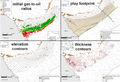
- ...tural gas, and condensate/natural gas liquids play in southwest to central Texas (Fig. 1). The Eagle Ford play extends from the Maverick Basin northeast to ...ly northwest to southeast trend. Eagle Ford oil is also widely produced in Texas and parts of Louisiana from wells in the overlying Austin Chalk.10 KB (1,550 words) - 21:50, 3 March 2022
- ...Texas Natural Resources Information, U.S. Geological Survey, University of Texas Bureau of Economic Geology<ref name=US2015>U.S. Energy Information Administ ...tural gas, and condensate/natural gas liquids play in southwest to central Texas, extending from the Maverick Basin northeast to the Karnes Trough, with som11 KB (1,594 words) - 19:15, 8 February 2024
- ...TotalNGP2000-2020 Barnett2019-20CommRpt.jpg|200px|thumb|{{figure number|1}}Texas Barnett Shale total natural gas production 2000 through July 2020, https:// ...TotalNGP2000-2020 Barnett2019-20CommRpt.jpg|200px|thumb|{{figure number|2}}Texas Barnet Shale condensate production 2000 through July 2020, https://www.rrc.3 KB (414 words) - 22:15, 2 June 2021
- ...ales span more than 16 counties and parishes along the boundary of eastern Texas and western Louisiana. Basement structures and salt movement influenced car ...Haynesville can be found at the Texas Railroad Commission https://www.rrc.texas.gov/oil-and-gas/major-oil-and-gas-formations/haynesville-bossier-shale/ and4 KB (628 words) - 23:05, 3 March 2022
Page text matches
File:Figure1EagleFord2019-20CommRept.jpg ...Texas Natural Resources Information, U.S. Geological Survey, University of Texas Bureau of Economic Geology (from U.S. EIA, January 21, 2015).(432 × 296 (123 KB)) - 21:52, 6 April 2021- ...ww-odp.tamu.edu/publications/tnotes/tn30/tn30_2.htm Ocean Drilling Program Texas A&M University article]258 bytes (35 words) - 16:37, 27 March 2015
File:M91FG193.JPG ...l for channelized turbidites and a basin-floor fan complex, Brushy Canyon, Texas. From Beaubouef (1999). Reprinted with permission from the AAPG.(800 × 1,075 (131 KB)) - 16:25, 14 August 2015
File:Paleontology fig3.png ...on of Rodessa Formation lithofacies at Running Duke Field, Houston County, Texas. Cores are indicated by solid vertical lines. (From Scott, 1990.)(1,973 × 1,229 (190 KB)) - 17:38, 14 January 2014- ...w.rrc.state.tx.us/oil-gas/major-oil-gas-formations/permian-basin/ State of Texas page, including drilling and production statistics]312 bytes (40 words) - 16:12, 15 December 2014
File:Subsurface-maps fig1.png Structure map of the top of the T5 marker, Frlo Formation, Brazoria County, Texas. (After Bebout et al., 1978.)(1,865 × 1,746 (308 KB)) - 20:42, 14 January 2014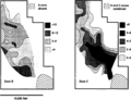
File:Subsurface-maps fig6.png ...he San Andres Formation reservoir, Jordan field, Ector and Crane Counties, Texas. Contours in PV fraction-feet. (After Major and Holtz, 1989.)(1,944 × 1,484 (237 KB)) - 20:42, 14 January 2014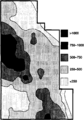
File:Subsurface-maps fig7.png ...he San Andres Formation reservoir, Jordan field, Ector and Crane counties, Texas. Contours in MSTB/year/acre. (After Major and Holtz, 1989.)(944 × 1,353 (62 KB)) - 20:42, 14 January 2014
File:FG18CoreSt63Appendix3.JPG ...nate reservoir: Fullerton Clear Fork (Lower Permian) field, Permian Basin, Texas: AAPG Studies in Geology 63.(600 × 890 (315 KB)) - 16:10, 29 June 2015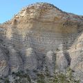
File:Eagle-ford-gets-spotlight04.jpg West Texas' Lozier Canyon offers an opportunity to examine Eagle Ford Shale outcrops a(400 × 400 (80 KB)) - 16:20, 18 June 2014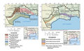
File:Figure3AustinChalk2019-20CommRept.jpg ...recoverable oil and gas resources in the Austin Chalk and related units in Texas and Louisiana. (Pitman et al., 2020).(1,789 × 1,110 (895 KB)) - 21:21, 5 April 2021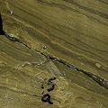
File:MainPageFG18CoreSt63Appendix3.jpg ...nate reservoir: Fullerton Clear Fork (Lower Permian) field, Permian Basin, Texas: AAPG Studies in Geology 63. Used on Core description article.(400 × 400 (104 KB)) - 16:14, 29 June 2015
File:M91Ch11FG70.JPG ...on a horizon display, late Pennsylvanian to Early Permian, Baylor County, Texas (from Burnett, 1996). From Shepherd, M., 2009, Lithofacies maps, in M. Shep(600 × 353 (134 KB)) - 15:46, 27 April 2015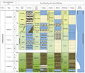
File:Figure1AustinChalk2019-20CommRept.jpg Stratigraphic columns for Upper Cretaceous rocks from South Texas to Mississippi (Pearson, 2012). Shows reservoir rocks (Austin Chalk, Tokio(579 × 499 (288 KB)) - 20:54, 5 April 2021
File:M91FG117.JPG ...aps from the West Cornelius reservoir, North Markham-North Bay City field, Texas. In this strand-plain reservoir, east-northeastndashwest-southwest-oriented(800 × 689 (66 KB)) - 21:32, 12 August 2015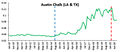
File:Figure2AustinChalk2019-20CommRept.jpg Austin Chalk production (combining Texas and Louisiana) from January 2010 through September 2020 in millions of barr(468 × 202 (56 KB)) - 21:13, 5 April 2021
File:M109CH01Monocrystalline.jpg Lower Cretaceous Travis Peak Formation, Eastland County, Texas, Monocrystalline quartz grain with exceptionally abundant vacuoles (probabl(656 × 439 (87 KB)) - 20:20, 23 January 2019
File:M91FG199.JPG ...rmian San Andres dolomite of the northern Delaware basin in New Mexico and Texas (after Shinn, 1983). Repeated transgression and regression create cycles of(800 × 1,089 (126 KB)) - 13:11, 20 August 2015- ...TotalNGP2000-2020 Barnett2019-20CommRpt.jpg|200px|thumb|{{figure number|1}}Texas Barnett Shale total natural gas production 2000 through July 2020, https:// ...TotalNGP2000-2020 Barnett2019-20CommRpt.jpg|200px|thumb|{{figure number|2}}Texas Barnet Shale condensate production 2000 through July 2020, https://www.rrc.3 KB (414 words) - 22:15, 2 June 2021
- ...-solutions.com/sunstar/geology/Permian/PermianTX.htm Permian reefs in west Texas, USA] ...geologicformations.htm Permian Reefs in Guadalupe Mountains National Park, Texas, USA] A significant part of of this park was donated to the country by Wal2 KB (298 words) - 21:30, 21 November 2014
- ...ales span more than 16 counties and parishes along the boundary of eastern Texas and western Louisiana. Basement structures and salt movement influenced car ...Haynesville can be found at the Texas Railroad Commission https://www.rrc.texas.gov/oil-and-gas/major-oil-and-gas-formations/haynesville-bossier-shale/ and4 KB (628 words) - 23:05, 3 March 2022
- ...gure number|1}}Stratigraphic columns for Upper Cretaceous rocks from South Texas to Mississippi <ref name=Pearson>Pearson, Krystal, 2012, Geologic models an ...taw Formations are time-equivalent stratigraphic units located east of the Texas-Louisiana border and are also productive for oil and gas. The Tokio, locate6 KB (846 words) - 20:58, 6 April 2021
- ....us/assets/public/implementation/barnett_shale/bs_images/bsOilGasWells.png Texas Commission on Environmental Quality]</ref>]] ...ssion for productive portions of the Barnett Shale Play area.<ref name=TRC>Texas Railroad Commission, [http://www.rrc.state.tx.us/oil-gas/major-oil-gas-form6 KB (909 words) - 19:24, 14 March 2019
- ...]] (1.5 sec) in the [[Cretaceous]] Escondido Sandstone in La Salle County, Texas. ...ft (1.5 sec) in the [[Cretaceous]] Escondido Sandstone in La Salle County, Texas. Modified. Copyright: Rice<ref name=Rice_1989>Rice, G., 1989, Exploration E3 KB (361 words) - 17:45, 12 April 2022
- '''By Charlie Y.C. Zheng, University of Texas at Austin, Austin, TX, USA''' ...stin Chalk Group was deposited on a broad carbonate shelf that trends from Texas into Louisiana and contains many major oil fields (Fig. 1) (Pitman et al.,8 KB (1,200 words) - 21:22, 3 March 2022
- ...Texas Natural Resources Information, U.S. Geological Survey, University of Texas Bureau of Economic Geology<ref name=US2015>U.S. Energy Information Administ ...tural gas, and condensate/natural gas liquids play in southwest to central Texas, extending from the Maverick Basin northeast to the Karnes Trough, with som11 KB (1,594 words) - 19:15, 8 February 2024
- ...ry Faults in Parts of North-Central and Western Houston Metropolitan Area, Texas]: U.S. Geological Survey Miscellaneous Field Studies Map 1136</ref> ...e, while the sediments were being deposited. Such faults are common in the Texas Gulf Coast. From USGS.<ref name=Verbeek-et-al />]]4 KB (630 words) - 18:28, 2 April 2019
- ...figure number|1}}example of a synthetic seismogram from the Midland basin, Texas.<ref name=ch21r44 />]] ...Figure 1]] is an example of a synthetic seismogram from the Midland basin, Texas.5 KB (746 words) - 16:54, 4 February 2022
- ...tural gas, and condensate/natural gas liquids play in southwest to central Texas (Fig. 1). The Eagle Ford play extends from the Maverick Basin northeast to ...ly northwest to southeast trend. Eagle Ford oil is also widely produced in Texas and parts of Louisiana from wells in the overlying Austin Chalk.10 KB (1,550 words) - 21:50, 3 March 2022
- ...eismic-data_fig12-3.png|thumb|500px|{{figure number|1}}3-D data from north Texas. From Liner.<ref name=Liner_1999>Liner, C., 1999. Elements of 3-D Seismolog ...reting-seismic-data_fig12-3.png|Figure 1]] illustrates 3-D data from north Texas. It measures about 1.5 mi<sup>2</sup> across the top. [[:file:interpreting-5 KB (813 words) - 19:05, 27 January 2022
- ...eak Formation, Western Flank of the Sabine Arch, East Texas: University of Texas at Austin Bureau of Economic Geology Report of Investigations 185, 55 p.5 KB (644 words) - 15:30, 3 February 2022
- ...Wu, and A. W. Balley, 193, Mesozoic and early Cenozoic development of the Texas margin: a new integrated cross-section from the Cretaceous shelf edge to th ...basin [[depocenter]] was focused offshore of western Louisiana and eastern Texas. The westernmost part of this depocenter appears to have been the input are11 KB (1,496 words) - 18:17, 22 February 2022
- ...M., 1993, Relative seal-level variations and fault-salt response: offshore Texas examples: Proceedings, Gulf Coast Section SEPM 14th Annual Research Confere ...ernary sedimentation and high-resolution sequence stratigraphy of the East Texas shelf, in DeBatist, M., Jacobs, P., eds., Geology of Siliciclastic Shelf Se5 KB (698 words) - 14:57, 23 February 2022
- ...r, F. A., 1973, A Handbook of Texas Abstractors and Title Men: Austin, TX, Texas Land Title Assoc., p. 1-321.</ref> ...U.S. Government, generally covers all lands west of the Mississippi except Texas, all states north of the Ohio River, and Alabama, Florida, and Mississippi.15 KB (2,269 words) - 19:25, 19 January 2022
- ...od efficiency at Jordan field, University Lands, Ector and Crane counties, Texas: 64th Annual Technology Conference of the Society of Petroleum Engineers, S ...nd their implications for geopressured fluid production: The University of Texas Bureau of Economic Geology Report of Investigations, n. 123, 70 pp.</ref>16 KB (2,282 words) - 20:46, 19 January 2022
- ...), Niobrara, and Permian. As of June 2021, the giant Permian Basin of West Texas and southeast New Mexico still produces most oils (around 4,500 thousand ba * [[Barnett Shale (Mississippian), Fort Worth Basin, Texas ]]9 KB (1,311 words) - 20:32, 20 September 2022
- ...geochemically and closely resemble continental shelf oils of Louisiana and Texas. The East Breaks 160-161 ''Glob alt'' and ''Hyal B'' oils do not correlate ...Wu, and A. W. Bally, 1993, Mesozoic and early Cenozoic development of the Texas margin: a new integrated cross-section from the Cretaceous shelf edge to th7 KB (1,080 words) - 17:44, 23 March 2022
- ...a065/0001/0000/0025.htm Facies controls on early diagenesis: Wilcox Group, Texas Gulf Coast], in D. Meshri and P. J. Ortoleva, eds., Prediction of Reservoir For example, different facies of the Wilcox Group along the Gulf Coast of Texas have different compositions that are independent of their source area.<ref8 KB (1,129 words) - 14:11, 6 April 2022
- ...depositional heterogeneity ranking of reservoir facies based primarily on Texas [[petroleum]] fields ...rotidal barrier system—Frio Formation, Texas Gulf Coast: The University of Texas Bureau of Economic Geology, Report of Investigations, v. 144, 36 p.</ref>)]8 KB (983 words) - 20:49, 19 January 2022
- ...cycles: a case study in High Island–Galveston–East Breaks areas, offshore Texas: Proceedings, Gulf Coast Section SEPM 11th Annual Research Conference, p. 2 In the Texas offshore Pliocene and Pleistocene depocenter, patterns of fossil abundance9 KB (1,143 words) - 14:57, 23 February 2022
- ...cycles: A case study in High Island-Galveston-East Breaks areas, offshore Texas: Proceedings, Gulf Coast Section SEPM 11th Annual Research Conference, p. 2 ...90, Miocene oil source beds in the East Breaks basin, Flex-Trend, offshore Texas: Proceedings, Gulf Coast Section SEPM 9th Annual Research conference, p. 136 KB (850 words) - 15:33, 23 March 2022
- ...C. Cobb, and M. L. Ivey, Jr., 1988, East Breaks 160 field on the offshore Texas shelf edge: a model for deepwater exploration and development: Proceedings, ...cycles: a case study in High Island–Galveston–East Breaks areas, offshore Texas: Proceedings, Gulf Coast Section SEPM 11th Annual Research Conference, p. 27 KB (952 words) - 18:44, 21 March 2022
- ...hemical methods discovered Agaritta and Brady Creek fields, Concho County, Texas]: AAPG Bulletin, vol. 77, p. 1219–1240.</ref> ...nologies: Unconventional Methods in Exploration for Oil and Gas V: Dallas, Texas, Southern Methodist Univ. Press, p. 309–322.</ref> and Tucker and Hitzman8 KB (1,055 words) - 16:29, 25 January 2022
- ...e Carlson shoreface reservoir of the North Markham-North City Bay field of Texas. The large size and excellent lateral continuity of shoreface reservoirs gi ...l Technical Conference of the Society of Petroleum Engineers, San Antonio, Texas, SPE Paper 19878, 18 p.</ref><ref>Black, R. C., H. J. Poelen, M. J. Roberts18 KB (2,607 words) - 15:33, 15 January 2024
- * [[Barnett Shale (Mississippian), Fort Worth Basin, Texas]] * [[Eagle Ford Group in southwest Texas (USGS)]]9 KB (1,373 words) - 20:57, 6 April 2021
- ...cycles: a case study in High Island–Galveston–East Breaks areas, offshore Texas: Proceedings, Gulf Coast Section SEPM 11th Annual Research Conference, p. 28 KB (1,015 words) - 16:59, 23 March 2022
- ...ine canyon fill reservoir complex, lower Wilcox Group (Paleocene), central Texas coastal plain, in R. D. Winn, Jr., and J. M. Armentrout, eds., Turbidites a ...cycles: a case study in High Island–Galveston–East Breaks areas, offshore Texas: Proceedings, Gulf Coast Section SEPM 11th Annual Research Conference, p. 27 KB (1,022 words) - 21:54, 22 March 2022
- [[file:Eagle-ford-gets-spotlight04.jpg|thumb|200px|West Texas' Lozier Canyon offers an opportunity to examine Eagle Ford Shale outcrops a4 KB (561 words) - 21:20, 1 February 2023
- ...0017.htm Fracture development and mechanical stratigraphy of Austin Chalk, Texas]: AAPG Bulletin, vol. 71, no. 1, p. 17–28.</ref> change ductility.4 KB (510 words) - 15:22, 30 March 2022
- ..., Impact of improved technology on potential reserves of tight gas in east Texas and north Louisiana: ICF-Lewin, Inc., Topical Report GRI-90/0174, 119 p.</r | East Texas || 6.03 || -9 KB (1,242 words) - 15:47, 11 March 2015
- ...ine canyon fill reservoir complex, lower Wilcox Group (Paleocene), central Texas coastal plain, in R. D. Winn, Jr., and J. M. Armentrout, eds., Turbidites a4 KB (494 words) - 13:44, 5 December 2023
- ...1980<ref name=Folk1980>Folk, R. L., 1980, Petrology of sedimentary rocks: Texas Hemphill’s Book Store, Austin, 182 p.</ref>) ...enter|400px|thumb|Lower Cretaceous Travis Peak Formation, Eastland County, Texas, monocrystalline quartz grain with exceptionally abundant vacuoles (probabl8 KB (1,127 words) - 20:21, 23 January 2019
- ...ventional Methods in Exploration for Petroleum and Natural Gas IV: Dallas, Texas, Southern Methodist Univ. Press, p. 81–129.</ref> The surface expression4 KB (605 words) - 19:24, 24 January 2022
- ...or low-permeability sandstone reservoirs in the continental United States: Texas Bureau of Economic Geology Report of Investigations 211, 221 p.</ref> also9 KB (1,373 words) - 13:40, 10 March 2015
- ...M., 1993, Relative seal-level variations and fault-salt response: offshore Texas examples: Proceedings, Gulf Coast Section SEPM 14th Annual Research Confere ...ecause the preceding shoreline break is tens of miles further north on the Texas shelf. Clarification of such scale-dependent reference points is critical t10 KB (1,394 words) - 21:47, 22 February 2022
- ...90, Miocene oil source beds in the East Breaks basin, Flex-Trend, offshore Texas: Proceedings, Gulf Coast Section SEPM 9th Annual Research conference, p. 135 KB (648 words) - 15:33, 23 March 2022
- ...nate reservoir: Fullerton Clear Fork (Lower Permian) field, Permian Basin, Texas: [http://archives.datapages.com/data/alt-browse/aapg-special-volumes/sg63.h ...c Taos trough, northern New Mexico: Ph. D. Dissertation, The University of Texas at Austin, 236 p.</ref><ref name=pt05r28 />.)]]13 KB (1,786 words) - 20:50, 19 January 2022
- ...ern area). A study by the Bureau of Economic Geology at the University of Texas at Austin found the play holds 38 Tcf in technically recoverable resources,5 KB (645 words) - 22:38, 2 June 2021
- ...e, April 15–20, 1999, Deep-water sandstones, Brushy Canyon Formation, west Texas: AAPG Continuing Education Course Note Series 40, 48 p.</ref>]] ...utcrop and waterflood simulation modeling of the 100-foot channel complex, Texas, and the Ainsa II channel complex, Spain: Analogs to multistory and multila20 KB (2,850 words) - 15:33, 15 January 2024
- ...ern area). A study by the Bureau of Economic Geology at the University of Texas at Austin found the play holds 38 Tcf in technically recoverable resources,4 KB (598 words) - 21:52, 3 March 2022
- ...M., 1993, Relative seal-level variations and fault-salt response: offshore Texas examples: Proceedings, Gulf Coast Section SEPM 14th Annual Research Confer- ...ic framework in the north-western portion of the Gulf basin: University of Texas at Austin, Bureau of Economic Geology Circular 74-1.</ref> with Beard et al13 KB (1,871 words) - 20:06, 24 February 2022
- * East Texas basin,4 KB (584 words) - 21:29, 13 October 2014
- ...C. Cobb, and M. L. Ivey, Jr., 1988, East Breaks 160 field on the offshore Texas shelf edge: a model for deepwater exploration and development: Proceedings,10 KB (1,376 words) - 16:00, 23 March 2022
- ...r potential for production of geopressured geothermal energy: The Univ. of Texas Bureau of Economic Geology Report of Investigations, n. 91, 93 p.</ref>]] ...he San Andres Formation reservoir, Jordan field, Ector and Crane Counties, Texas. Contours in PV fraction-feet. (After Major et al.)<ref name=pt06r81>Major,22 KB (3,076 words) - 13:56, 24 January 2022
- ...g/0055/0011/2000/2008.htm Deep test in Ouachita structural belt of Central Texas]: AAPG Bulletin, vol. 56, p. 2008–2017.</ref>11 KB (1,525 words) - 18:50, 1 February 2022
- ...M., 1993, Relative seal-level variations and fault-salt response: offshore Texas examples: Proceedings, Gulf Coast Section SEPM 14th Annual Research Confere5 KB (662 words) - 14:48, 19 December 2023
- ...on diagenesis and reservoir quality in Lower Tertiary sandstones along the Texas Gulf Coast], in D. A. McDonald and R. C. Surdam, eds., Clastic Diagenesis:5 KB (729 words) - 20:48, 5 April 2022
- ...cycles: a case study in High Island–Galveston–East Breaks areas, offshore Texas: Proceedings, Gulf Coast Section SEPM 11th Annual Research Conference, p. 2 ...e High Island–East Addition area just west of the seaward extension of the Texas/Louisiana border.11 KB (1,548 words) - 16:58, 24 February 2022
- ...90, Miocene oil source beds in the East Breaks basin, Flex-Trend, offshore Texas: Proceedings, Gulf Coast Section SEPM 9th Annual Research conference, p. 135 KB (715 words) - 17:07, 23 March 2022
- ...he modern reefs in the Bahamas or the ancient Permian reef complex of West Texas could be a valuable guide to interpretation.5 KB (730 words) - 22:36, 1 February 2022
- ...90, Miocene oil source beds in the East Breaks basin, Flex-Trend, offshore Texas: Proceedings, Gulf Coast Section SEPM 9th Annual Research Conference, p. 13 ...ernary sedimentation and high-resolution sequence stratigraphy of the East Texas shelf, in DeBatist, M., Jacobs, P., eds., Geology of Siliciclastic Shelf Se11 KB (1,482 words) - 15:47, 21 March 2022
- ...regions, with heavy concentration of production centered in the states of Texas, Oklahoma, Kansas, Nebraska, New Mexico, Michigan, Ohio, and Kentucky. Grea5 KB (768 words) - 18:39, 1 August 2016
- ...ventional Methods in Exploration for Petroleum and Natural Gas IV: Dallas, Texas, Southern Methodist Univ. Press, p. 81–129.</ref><ref name=ch18r18>Klusma6 KB (754 words) - 22:07, 24 January 2022
- ...ef>Folk, R. L., 1968, Petrology of sedimentary rocks, 2nd edition: Austin, Texas, Hemphill’s, 170 p.</ref>; Picard<ref>Picard, D. M., 1971, Classification ...d M. Dumitrescu, 2013, An SEM study of porosity in the Eagle Ford Shale of Texas, in W. K. Camp, E. Diaz, and B. Wawak, eds., Electron microscopy of shale h16 KB (2,352 words) - 18:46, 4 December 2023
- * [[Permian Basin, West Texas 2017-18]]6 KB (820 words) - 20:57, 6 April 2021
- ...nologies: Unconventional Methods in Exploration for Oil and Gas V: Dallas, Texas, Southern Methodist Univ. Press, p. 309–322.</ref>6 KB (826 words) - 17:33, 25 January 2022
- ...cycles: a case study in High Island–Galveston–East Breaks areas, offshore Texas: Proceedings, Gulf Coast Section SEPM 11th Annual Research Conference, p. 27 KB (901 words) - 20:45, 22 February 2022
- ...d Research International Conference on Heavy Crude and Tar Sands (Houston, Texas, February 1995), v. 1, p. 203-211.</ref>7 KB (1,012 words) - 13:40, 18 March 2019
- ...90, Miocene oil source beds in the East Breaks basin, Flex-Trend, offshore Texas: Proceedings, Gulf Coast Section SEPM 9th Annual Research conference, p. 136 KB (929 words) - 19:41, 22 March 2022
- ...M., 1993, Relative seal-level variations and fault-salt response: offshore Texas examples: Proceedings, Gulf Coast Section SEPM 14th Annual Research Confere ...cycles: a case study in High Island–Galveston–East Breaks areas, offshore Texas: Proceedings, Gulf Coast Section SEPM 11th Annual Research Conference, p. 215 KB (2,029 words) - 21:21, 23 February 2022
- ...cycles: a case study in High Island–Galveston–East Breaks areas, offshore Texas: Proceedings, Gulf Coast Section SEPM 11th Annual Research Conference, p. 27 KB (895 words) - 16:18, 24 March 2022
- ...T., and J. Leftwich, 1993, An analysis of geopressure profiles from south Texas: the search for higher quality reservoirs in the Tertiary sections of the G6 KB (930 words) - 15:49, 30 March 2022
- * State agencies (e.g., Railroad Commission in Texas)6 KB (779 words) - 15:09, 24 January 2022
- ...062.htm 3-D seismic expression of a shallow fluvial system in west central Texas], ''in'' P. Weimer and T. L. Davis, eds., Applications of 3-D Seismic Data ...Tertiary sandstone-shale sequence model, Powderhorn field, Calhoun County, Texas]: AAPG Bulletin, v. 80, no. 1, p. 16–45.</ref> These included coastal str21 KB (3,139 words) - 16:54, 6 April 2016
- ...Curiale;<ref name=ch08r10>Curiale, J., A., 1992, Petroleum geochemistry of Texas and Oklahoma oils from the Marathon/Ouachita foldbelt: Chemical Geology, vo ...rrelations_fig8-12.png|Figure 8]] shows gas chromatograms of two oils from Texas and Oklahoma. Full-scale chromatograms on the left show the oils are not [[22 KB (3,123 words) - 21:38, 15 February 2022
- Such consistent salinity increase with depth is not unique to the [[East Texas basin]] but is characteristic of most basins.7 KB (895 words) - 18:57, 16 February 2022
- ...iocene and Pleistocene depocenters, outer continental shelf, Louisiana and Texas]: AAPG Bulletin, vol. 57, p. 2428–2439.</ref> The further mixing of strat7 KB (984 words) - 15:13, 4 January 2024
- ...Behrens, and R. T. Buffler, 1989, Distribution and movement of salt on the Texas–Louisiana continental slope, Garden Banks and eastern East Breaks areas, ...Wu, and A. W. Bally, 1993, Mesozoic and early Cenozoic development of the Texas margin: A new integrated hydrocarbon system study, northern Gulf of Mexico7 KB (970 words) - 20:33, 18 February 2022
- ...rotidal barrier system—Frio Formation, Texas Gulf Coast: The University of Texas Bureau of Economic Geology, Report of Investigations, v. 144, 36 p.</ref>.)17 KB (2,232 words) - 21:22, 19 January 2022
- ...Wu, and A. W. Bally, 1993, Mesozoic and early Cenozoic development of the Texas margin: a new integrated cross-section from the Cretaceous shelf edge to th7 KB (1,044 words) - 16:34, 22 February 2022
- ...on of Rodessa Formation lithofacies at Running Duke Field, Houston County, Texas. Cores are indicated by solid vertical lines. (From Scott.<ref name=pt05r14 ...r Cretaceous [[reef]] complexes of the Running Duke Field, Houston County, Texas. In these reef complexes, reservoir properties are partially controlled by17 KB (2,331 words) - 20:11, 10 August 2016
- ...-Trail et al., 2019), which is equivalent to the upper Eagle Ford Shale in Texas. Workers also identified that the maximum flooding surface occurs in the m7 KB (1,007 words) - 21:15, 3 March 2022
- ...gases and condensates from Block 551A High Island South Addition offshore Texas, Gulf of Mexico, in D. Schumacher, and B. F. Perkins, eds., Gulf Coast Oils8 KB (1,193 words) - 18:51, 1 February 2022
- The Permian basin of West Texas and southeast New Mexico ([[:file:GiacomoneEtAlFigure6.jpg|Figure 6]]) is t ...ce-April 15–20, 1999: Deep-water sandstones, Brushy Canyon Formation, West Texas. Continuing Education Course Note Series, 40.</ref>27 KB (3,791 words) - 19:35, 11 October 2022
- ...., 1987, Fracture Development and Mechanical Stratigraphy of Austin Chalk, Texas, The American Association of Petroleum Geologists Bulletin ...on Controlled by Carbonate Mechanical Stratigraphy, Balcones Fault System, Texas, The American Association of Petroleum Geologists Bulletin23 KB (3,162 words) - 17:28, 5 December 2023
- ...on diagenesis and reservoir quality in Lower Tertiary sandstones along the Texas Gulf Coast], in D. A. McDonald and R. C. Surdam, eds., Clastic Diagenesis:10 KB (1,384 words) - 15:00, 6 April 2022
- ...from the Ellenburger Group (Lower Ordovician) of west Texas: The Univ. of Texas Bureau of Economic Geology Report of Invetigations, n. 186, 40 p.</ref>]]23 KB (3,026 words) - 20:48, 19 January 2022
- ...voirs: Bureau of Economic Geology, Geological Circular 96-1, University of Texas at Austin, 30 p.</ref> ...rmian San Andres dolomite of the northern Delaware basin in New Mexico and Texas (after Shinn).<ref name=Shinn> Shinn, E. A., 1983, [http://archives.datapag38 KB (5,571 words) - 15:31, 16 January 2024
- ...ventional Methods in Exploration for Petroleum and Natural Gas IV: Dallas, Texas, Southern Methodist Univ. Press, p. 81–129.</ref> Richers and Maxwell<ref10 KB (1,443 words) - 16:08, 25 January 2022
- ...hrens E. W., and L. S. Land, 1972, Subtidal Holocene dolomite, Baffin Bay, Texas: Jour. Sed. Petrology, v. 42, p. 155-161.</ref> and sodium.<ref name=Landan9 KB (1,409 words) - 19:14, 3 March 2016


